
Texas Hill Country Travel Guide
Geographic region of Central and South Texas, considered the border between the American Southeast and Southwest and is notable for its karst topography and tall rugged hills of limestone or granite
Places to See in Texas Hill Country
Jeff P from Berkeley, CA, USA, CC BY 2.0, via Wikimedia Commons; Image Size Adjusted
.jpg)
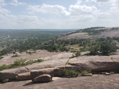
Enchanted Rock State Natural Area
Largest pink granite monadnock in the United States covers roughly 640 acres (260 ha) and rises around 425 feet (130 m) above the surrounding terrain to an elevation of 1,825 feet (556 m) above sea level
Jeff P from Berkeley, CA, USA, CC BY 2.0, via Wikimedia Commons; Image Size Adjusted
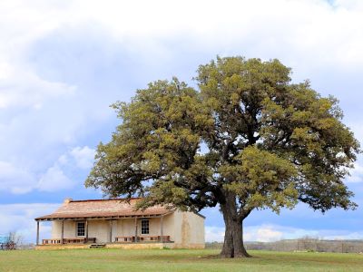
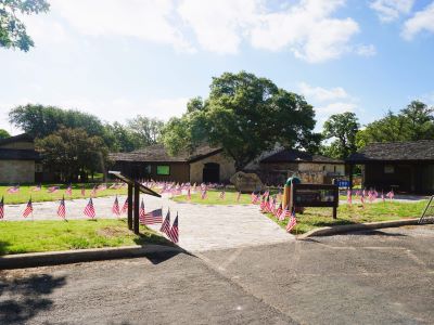
Fort Martin Scott State Historic Site
Military post established in 1848 as the region's first frontier fort built to protect settlers from Native American raids, featuring a reconstructed stone guardhouse and interpretive buildings that bring the antebellum frontier to life.

Jeff P from Berkeley, CA, USA, CC BY 2.0, via Wikimedia Commons; Image Size Adjusted
Fredericksburg
German inspired Texas town with Fredericksburg Historic District added to the National Register of Historic Places in Texas
Jeff P from Berkeley, CA, USA, CC BY 2.0, via Wikimedia Commons; Image Size Adjusted
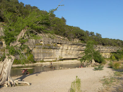
Garner State Park
State park situated along the Frio River offering camping, swimming, tubing, canoeing, kayaking, and hiking amid limestone bluffs and clear cypress-shaded waters.
Jeff P from Berkeley, CA, USA, CC BY 2.0, via Wikimedia Commons; Image Size Adjusted
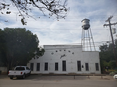
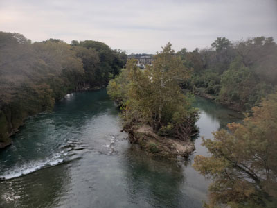
Gruene
Historic district centered on Texas's oldest continually operating dance hall, set along the Guadalupe River within New Braunfels.
Jeff P from Berkeley, CA, USA, CC BY 2.0, via Wikimedia Commons; Image Size Adjusted
Guadalupe River State Park
Texas state park located on a section of the Guadalupe River with four miles of river frontage for canoeing, fishing, swimming and tubing
Jeff P from Berkeley, CA, USA, CC BY 2.0, via Wikimedia Commons; Image Size Adjusted
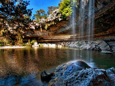
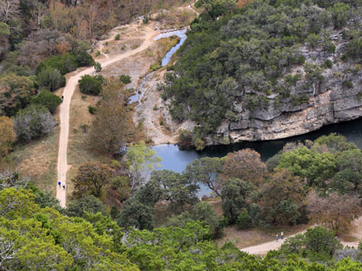
Hamilton Pool Preserve
Natural pool that was created when the dome of an underground river collapsed due to massive erosion thousands of years ago. Habitat featuring a jade green pool into which a 50-foot (15 m) waterfall flows with water temperatures reaching 50 degrees Fahrenheit
Jeff P from Berkeley, CA, USA, CC BY 2.0, via Wikimedia Commons; Image Size Adjusted
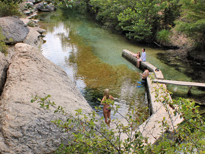
Jacobs Well
Popular local swimming spot where from the opening in the creek bed, Jacob's Well cave descends vertically for about 30 feet (9.1 m), then continues downward finally reaching an average depth of 120 feet (37 m)
Jeff P from Berkeley, CA, USA, CC BY 2.0, via Wikimedia Commons; Image Size Adjusted
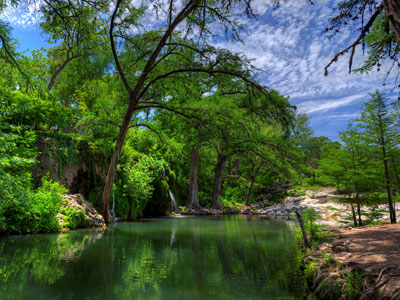
Krause Springs
115-acre (0.47 km2) property has 32 springs, and several feed the man-made pool and the natural pool which flow into Lake Travis
Jeff P from Berkeley, CA, USA, CC BY 2.0, via Wikimedia Commons; Image Size Adjusted
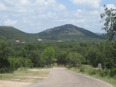
Lost Maples State Natural Area
Large, pristine area of beautiful hills and canyons on the upper Sabinal River in the Edwards Plateau Region of Texas
-400.jpg)
Jeff P from Berkeley, CA, USA, CC BY 2.0, via Wikimedia Commons; Image Size Adjusted
Lyndon B. Johnson National Historical Park
National park preserving the full life story of America's 36th president, spanning two Texas Hill Country districts from his boyhood home to his final resting place at the family ranch.
Jeff P from Berkeley, CA, USA, CC BY 2.0, via Wikimedia Commons; Image Size Adjusted
Lyndon B. Johnson State Park and Historic Site
Texas State Park adjacent to the LBJ Ranch featuring a living history farm, American bison, nature trails, and the visitor gateway for the LBJ National Historical Park.
Jeff P from Berkeley, CA, USA, CC BY 2.0, via Wikimedia Commons; Image Size Adjusted
National Museum of the Pacific War
World-class museum dedicated to the American experience in the Pacific Theater of World War II, built in the birthplace of Fleet Admiral Chester W. Nimitz.
Jeff P from Berkeley, CA, USA, CC BY 2.0, via Wikimedia Commons; Image Size Adjusted
New Braunfels
City known for its German Texan heritage and situated along the Balcones Fault, where the Texas Hill Country meets rolling prairie land
Jeff P from Berkeley, CA, USA, CC BY 2.0, via Wikimedia Commons; Image Size Adjusted
Pace Bend Park
Travis County park on a limestone peninsula jutting into Lake Travis, offering camping, swimming, cliff jumping, kayaking, and miles of rugged hiking trails with sweeping lake views.
Jeff P from Berkeley, CA, USA, CC BY 2.0, via Wikimedia Commons; Image Size Adjusted
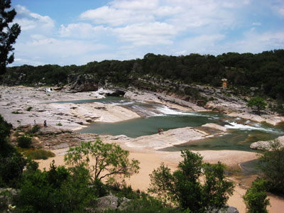
Pedernales State Park
5,212-acre state park situated along the banks of the Pedernales River in Blanco County, Texas
Jeff P from Berkeley, CA, USA, CC BY 2.0, via Wikimedia Commons; Image Size Adjusted
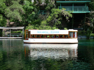
San Marcos
Founded on the banks of the San Marcos River, the area is thought to be among the oldest continuously inhabited sites in the Americas
The Texas Hill Country is a geographic region of Central and South Texas, forming the southeast part of the Edwards Plateau. Given its location, climate, terrain, and vegetation, the Hill Country can be considered the border between the American Southeast and Southwest. The region represents the very remote countryside of Central Texas but also is home to growing suburban neighborhoods and affluent retirement communities.
The region is notable for its karst topography and tall rugged hills of limestone or granite. Many of the hills rise to a height of 400-500 feet (120-150 m) above the surrounding plains and valleys, with Packsaddle Mountain rising to a height of 800 feet (240 m) above the Llano River in Kingsland. The Hill Country also includes the Llano Uplift and the second-largest granite dome in the United States, Enchanted Rock. The terrain throughout the region is punctuated by a thin layer of topsoil and many exposed rocks and boulders, making the region very dry and prone to flash flooding. Native vegetation in the region includes various yucca, prickly pear cactus, desert spoon, and wildflowers in the Llano Uplift. The predominant trees in the region are ashe juniper and Texas live oak.
Bound on the east by the Balcones Escarpment, the Hill Country reaches into the far northern portions of San Antonio and the western portions of Austin. As a result of springs discharging water stored in the Edwards Aquifer, several cities such as Austin, San Marcos, and New Braunfels were settled at the base of the Balcones Escarpment. The region's economy is one of the fastest growing in the United States.
Because of its karst topography, the area also features a number of caverns, such as Inner Space Caverns, Natural Bridge Caverns, Bracken Cave, Longhorn Cavern State Park, Cascade Caverns, Caverns of Sonora and Cave Without a Name. The deeper caverns of the area form several aquifers which serve as a source of drinking water for the residents of the area. Wonder Cave in San Marcos was formed by an earthquake along the Balcones Fault.
Several tributaries of the Colorado River of Texas — including the Llano and Pedernales rivers, which cross the region west to east and join the Colorado as it cuts across the region to the southeast - drain a large portion of the Hill Country. The Guadalupe, San Antonio, Frio, Medina, and Nueces rivers originate in the Hill Country.
This article uses material from the Wikipedia article "Texas Hill Country", which is released under the Creative Commons Attribution-Share-Alike License 3.0