Sequoia National Park Travel Guide
Known for its giant sequoia trees, including the General Sherman tree, the largest tree on Earth by volume, the Giant Forest, which contains five of the ten largest trees in the world, and the highest point in the contiguous United States, Mount Whitney
Foothills Visitor Center
From October 1 to mid-March, hours are 9am to 4pm. From mid-March to September 30, open 8am to 4:30pm.
Lodgepole Visitor Center
From September 23 through October 14, hours are 8am to 4:30pm The visitor center will be closed for the season on October 15, reopening in May.
Cedar Grove Visitor Center
Cedar Grove Visitor Center is currently closed. In summer, the visitor center is open 9am to 5pm. The visitor center generally closes after Labor Day weekend. The road into to Cedar Grove is open until noon on November 16, 2020.
Mineral King Ranger Station
Open daily, May 24th - September 23rd, 8am to 4pm.
This pass is valid for 1-7 days and includes everyone traveling in a single vehicle for Sequoia & Kings Canyon National Parks and Hume Lake District of Sequoia National Forest/Giant Sequoia National Monument.
Accepts America The Beautiful Pass
From Fresno: Get on CA-41 S. Follow CA-99 S to CA-198 E in Tulare County. Take exit 97 from CA-99 S. Merge onto CA-198 E.
Overview
Sequoia National Park is located in southern Sierra Nevada east of Visalia, California. The park was established on September 25, 1890 to protect 404,064 acres (631 sq mi) of forested mountainous terrain. Encompassing a vertical relief of nearly 13,000 feet, the park contains the highest point in the contiguous United States, Mount Whitney, at 14,505 feet above sea level. The park is south of, and contiguous with, Kings Canyon National Park; both parks are administered by the National Park Service together as the Sequoia and Kings Canyon National Parks.
The park is notable for its giant sequoia trees, including the General Sherman tree, the largest tree on Earth by volume. The General Sherman tree grows in the Giant Forest, which contains five of the ten largest trees in the world. The Giant Forest is connected by the Generals Highway to Kings Canyon National Park's General Grant Grove, home of the General Grant tree among other giant sequoias. The park's giant sequoia forests are part of 202,430 acres (316 sq mi) of old-growth forests shared by Sequoia and Kings Canyon National Parks. The parks preserve a landscape that still resembles the southern Sierra Nevada before Euro-American settlement.
Front country
Many park visitors enter Sequoia National Park through its southern entrance near the town of Three Rivers at Ash Mountain at 1,700 ft elevation. The lower elevations around Ash Mountain contain the only National Park Service-protected California Foothills ecosystem, consisting of blue oak woodlands, foothills chaparral, grasslands, yucca plants, and steep, mild river valleys. The region is also home to abundant wildlife: bobcats, foxes, ground squirrels, rattlesnakes, and mule deer are commonly seen in this area, and more rarely, reclusive mountain lions and the Pacific fisher are seen as well.
At higher elevations in the front country, between 5,500 and 9,000 feet in elevation, the landscape becomes montane forest-dominated coniferous belt. Found here are Ponderosa, Jeffrey, sugar, and lodgepole pine trees, as well as abundant white and red fir. Found here too are the giant sequoia trees, the most massive living single-stem trees on earth. Between the trees, spring and summer snowmelts sometimes fan out to form lush, though delicate, meadows. In this region, visitors often see mule deer, Douglas squirrels, and American black bears.
Back country
The vast majority of the park is roadless wilderness; no road crosses the Sierra Nevada within the park's boundaries. 84 percent of Sequoia and Kings Canyon National Parks is designated wilderness and is accessible only by foot or by horseback. The majority was designated Sequoia-Kings Canyon Wilderness in 1984 and the southwest portion was protected as John Krebs Wilderness in 2009.
Sequoia's backcountry offers a vast expanse of high-alpine wonders. Covering the highest-elevation region of the High Sierra, the backcountry includes Mount Whitney on the eastern border of the park, accessible from the Giant Forest via the High Sierra Trail. On a traveler's path along this 35-mile backcountry trail, one passes through about 10 miles of montane forest before reaching the backcountry resort of Bearpaw Meadow, just short of the Great Western Divide.
Mount Whitney
Continuing along the High Sierra Trail over the Great Western Divide via Kaweah Gap, one passes from the Kaweah River Drainage, with its characteristic V-shaped river valleys, and into the Kern River drainage, where an ancient fault line has aided glaciers in the last ice age to create a U-shaped canyon that is almost perfectly straight for nearly 20 miles (32 km). On the floor of this canyon, at least two days hike from the nearest road, is the Kern Canyon hot spring, a popular resting point for weary backpackers. From the floor of Kern Canyon, the trail ascends again over 8,000 ft (2,400 m) to the summit of Mount Whitney. At Mount Whitney, the High Sierra Trail meets with the John Muir Trail and the Pacific Crest Trail, which continue northward along the Sierra crest and into the backcountry of Kings Canyon National Park.
Most of the mountains and canyons in the Sierra Nevada are composed of granitic rocks. These rocks, such as granite, diorite and monzonite, formed when molten rock cooled far beneath the surface of the earth. The molten rock was the result of a geologic process known as subduction. Powerful forces in the earth forced the landmass under the waters of the Pacific Ocean beneath and below an advancing North American Continent. Super-hot water driven from the subducting ocean floor migrated upward and melted rock as it proceeded. This process took place during the Cretaceous Period, 100 million years ago. Granitic rocks have a speckled salt-and-pepper appearance because they contain various minerals including quartz, feldspars and micas. Valhalla, or the Angel Wings, are prominent granitic cliffs that rise above the headwaters of the Middle Fork of the Kaweah River.
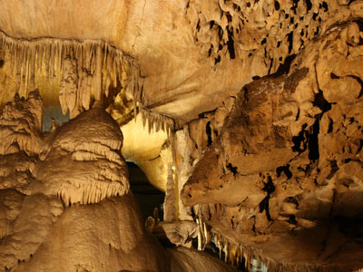
The park contains more than 270 known caves, including Lilburn Cave which is California's longest cave with nearly 17 miles (27 km) of surveyed passages. The only commercial cave open to park visitors is Crystal Cave, the park's second-longest cave at over 3.4 miles (5.5 km). Crystal Cave was discovered on April 28, 1918 by Alex Medley and Cassius Webster. The cave is a constant 48 °F (9 °C), and is only accessible by guided tour.
Park attractions
Crescent Meadow in the Giant Forest, called the "Gem of the Sierra" by John Muir. Crescent Meadow is a small, sequoia-rimmed meadow in the Giant Forest region of Sequoia National Park. This sierran montane meadow marks the western terminus of the High Sierra Trail, which stretches from the meadow across the Great Western Divide to Mount Whitney. Pioneer Hale Tharp homesteaded in this and nearby Log Meadow. Conservationist John Muir visited this meadow many times and praised it highly calling it the "Gem of the Sierra". The meadow lies at the end of a three-mile paved road which leaves the Generals Highway near the Giant Forest Museum.
In addition to hiking, camping, fishing, and backpacking, the following attractions are highlights with many park visitors:
Sherman Tree Trail An 0.8-mile roundtrip paved trail that descends from the parking lot to the base of the General Sherman tree and meanders through a grove of giant sequoia trees.
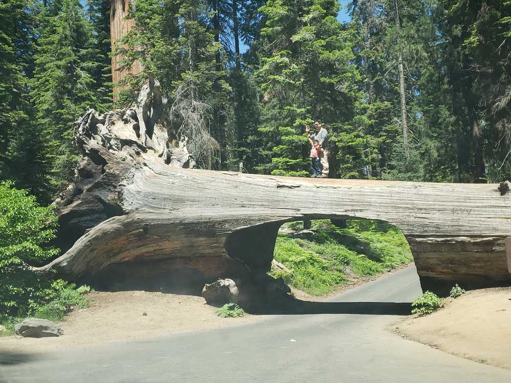
Tunnel Log is a fallen giant sequoia tree in Sequoia National Park. The tree, which measured 275 feet tall and 21 feet in diameter, fell across a park road in 1937 due to natural causes. The following year, a crew cut an 8-foot tall, 17-foot wide tunnel through the trunk, making the road passable again.
Tokopah Falls: The trail to Tokopah Falls starts just beyond the Marble Fork Bridge in Lodgepole Campground. It is an easy 1.7 mile (one way) walk along the Marble Fork of the Kaweah River to the impressive granite cliffs and waterfall of Tokopah Canyon. Tokopah Falls is 1,200 feet high, and is most impressive in early summer.
Moro Rock is a granite dome located in the center of the park, at the head of Moro Creek, between Giant Forest and Crescent Meadow. A 351-step stairway, built in the 1930s by the Civilian Conservation Corps, is cut into and poured onto the rock, so that visitors can hike to the top. The stairway is listed on the National Register of Historic Places. The view from the rock encompasses much of the Park, including the Great Western Divide. It has an elevation of 6,725 feet (2,050 m).
Giant Forest Museum offers information about giant sequoias and human history in the forest. The historic museum was built in 1928 by architect Gilbert Stanley Underwood.
This article uses material from the Wikipedia article "Sequoia National Park ", which is released under the Creative Commons Attribution-Share-Alike License 3.0
This article uses material from nps.gov "Sequoia & Kings Canyon National Parks"
Featured Locations and Trails
Jeff P from Berkeley, CA, USA, CC BY 2.0, via Wikimedia Commons; Image Size Adjusted
Jeff P from Berkeley, CA, USA, CC BY 2.0, via Wikimedia Commons; Image Size Adjusted
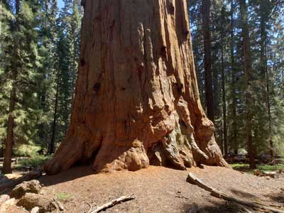
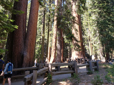
General Sherman Tree
The world's largest tree, measured by volume. It stands 275 feet (83 m) tall, and is over 36 feet (11 m) in diameter at the base

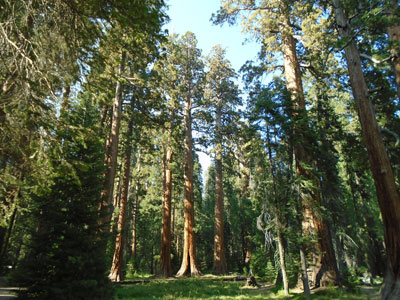
Giant Forest
Famed for its giant sequoia trees, five of the ten most massive trees on the planet, is the most accessible of all giant sequoia groves, as it has over 40 miles of hiking trails
.jpg)
-400.jpg)
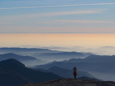
Mineral King
Subalpine glacial valley accessed by a long and narrow winding road, the valley is mostly popular with backpackers and hikers
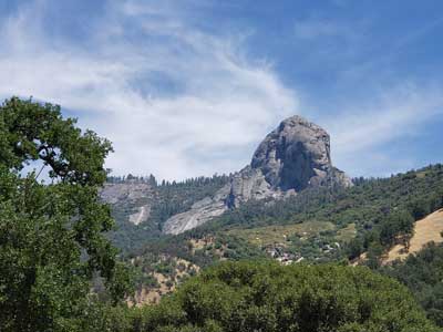
Moro Rock
0.4 miles roundtrip, 187 feet
Granite dome rock formation with views from the rock encompasses much of the park, including the Great Western Divide
-400.jpg)
Mount Whitney
Tallest mountain in the contiguous United States and the Sierra Nevada, with an elevation of 14,505 feet (4,421 m)