Coastal community set along a deep-water fjord surrounded by towering mountains, glaciers, and abundant marine and alpine wildlife.
Visitor information services typically available daily from 9am to 5pm
Local business hours vary by season
Costs vary for tours, activities, lodging, and excursions
How to Get There
From Anchorage (300 mi): Take AK-1 N (Glenn Highway) toward Glennallen, then follow AK-4 S (Richardson Highway) through Thompson Pass and Keystone Canyon directly into town.
Overview
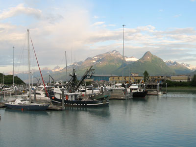
The Valdez area offers one of the most dramatic landscapes in Alaska, where glaciers spill down from rugged peaks into sheltered waters and waterfalls cascade through steep canyon walls. Positioned along the edge of a deep fjord, the community is a gateway to outdoor adventure, from kayaking among icebergs to cruising alongside tidewater glaciers. The surrounding terrain supports a rich diversity of wildlife, including whales, sea otters, and eagles, while inland trails wind through dense forests and alpine environments shaped by heavy snowfall and glacial activity.
Historically, the town emerged as a vital port during the gold rush era and later became a key transportation hub and the southern terminus of the Trans-Alaska Pipeline, solidifying its economic importance. Despite the devastation of the 1964 earthquake and the impact of the Exxon Valdez oil spill decades later, the community has demonstrated resilience and continues to thrive as both a working port and an adventure destination. Today, visitors are drawn by its unique blend of history, culture, and raw natural beauty, making it a compelling stop for those seeking an authentic and immersive Alaskan experience.
This article uses material from the Wikipedia articles and official tourism pages for Valdez, which are released under the Creative Commons Attribution-Share-Alike License 3.0.