
.jpg)
A vast protected wilderness encompassing massive glaciers, rugged mountain ranges, and remote valleys offering unparalleled opportunities for exploration and outdoor adventure.
How to Get There
From Anchorage (200+ mi): Take Glenn Hwy (AK-1 E) toward Glennallen, then connect to Richardson Hwy (AK-4) and follow signs to various park access points such as Nabesna Road or McCarthy Road depending on your destination.
Overview
Wrangell—St. Elias National Park and Preserve is a national park in south central Alaska. The park and preserve were established in 1980 by the Alaska National Interest Lands Conservation Act. The protected areas are included in an International Biosphere Reserve and are part of the Kluane/Wrangell-St. Elias/Glacier Bay/Tatshenshini-Alsek UNESCO World Heritage Site. The park and preserve form the largest area managed by the National Park Service with a total of 13,175,799 acres (20,587.186 sq mi; 53,320.57 km2), an expanse that could encapsulate six Yellowstone National Parks. The park includes a large portion of the Saint Elias Mountains, which include most of the highest peaks in the United States and Canada, yet are within 10 miles (16 km) of tidewater, one of the highest reliefs in the world. Wrangell-St. Elias borders on Canada's Kluane National Park and Reserve to the east and approaches another national park to the south, Glacier Bay. The chief distinction between park and preserve lands is that sport hunting is prohibited in the park and permitted in the preserve. In addition, 9,078,675 acres (3,674,009 ha) of the park and preserve are designated as the largest single wilderness in the United States.
The park has long, extremely cold winters and a short summer season. Plate tectonics are responsible for the uplift of the mountain ranges that cross the park. The park's extreme high point is Mount Saint Elias at 18,008 feet (5,489 m), the second tallest mountain in both the United States and Canada. The park has been shaped by the competing forces of volcanism and glaciation. Mount Wrangell is an active volcano, one of several volcanoes in the western Wrangell Mountains. In the St. Elias Range, Mount Churchill has erupted explosively within the past 2,000 years. The park's glacial features include Malaspina Glacier, the largest piedmont glacier in North America, Hubbard Glacier, the longest tidewater glacier in Alaska, and Nabesna Glacier, the world's longest valley glacier. The Bagley Icefield covers much of the park's interior, which includes 60% of the permanently ice-covered terrain in Alaska. At the center of the park, the boomtown of Kennecott exploited one of the world's richest deposits of copper from 1903 to 1938. The abandoned mine buildings and mills comprise a National Historic Landmark district.
Wrangell-St. Elias National Park and Preserve includes the entire Wrangell range, the western portion of the Saint Elias Mountains and the eastern portion of the Chugach Mountains. Lesser ranges in the park or preserve include the Nutzotin Mountains, which are an extension of the Alaska Range, the Granite Range and the Robinson Mountains. Broad rivers run in glacial valleys between the ranges, including the Chitina River, Chisana River and the Nabesna River. All but the Chisana and Nabesna are tributaries to the Copper River, which flows along the western margin of the park and which has its headwaters within the park, at the Copper Glacier. The park includes dozens of glaciers and icefields. The Bagley Icefield covers portions of the St. Elias and Chugach ranges, and Malaspina Glacier covers most of the southeastern extension of the park, with Hubbard Glacier at the park's extreme eastern boundary, the largest tidewater glacier in North America. The eastern boundary of the park is Alaska's border with Canada, where it is adjoined by Kluane National Park and Reserve.
On the southeast the park is bounded by Yakutat Bay, Tongass National Forest and the Gulf of Alaska. The remainder of the southern boundary follows the crest of the Chugach Mountains, adjoining Chugach National Forest. The western boundary is the Copper River, and the northern boundary follows the Mentasta Mountains and borders Tetlin National Wildlife Refuge.
Mount St. Elias is the second highest mountain in both Canada and the United States. Nine of the 16 highest peaks on U.S. soil are located in the park, along with North America's largest subpolar icefield, glaciers, rivers, an active volcano, and the historic Kennecott copper mines. Both the St. Elias and Wrangell ranges have seen volcanic activity. The St. Elias volcanoes are considered extinct, but some of the volcanoes of the Wrangell Range have been active in Holocene time. Ten separate volcanoes have been documented in the western Wrangell Range, of which Mount Blackburn is the highest and Mount Wrangell is the most recently active. Mount St. Elias is situated on the border of Wrangell-St. Elias National Park and Kluane National Park and Reserve. At 18,074 feet (5,509 m).
The park is accessible by highway from Anchorage; two rough gravel roads (the McCarthy Road and the Nabesna Road) wind through the park which makes portions of the interior accessible for backcountry camping and hiking. Chartered aircraft also fly into the park. The park area includes a few small settlements. Nabesna and Chisana are in the northern part of the park. Kennicott and McCarthy are relatively close together in the center of the park, with a few smaller settlements nearby and along the 60-mile (97 km) McCarthy Road. Chitina serves as a gateway community where the McCarthy Road meets the Edgerton Highway along the Copper River. The McCarthy Road and the Nabesna Road are the only significant roads in the park.
Access to the park is open all year, and most of the park facilities are open from May to September, although some locations open as late as the end of May and close in mid-August.
The Edgerton Highway runs along the valley of the Copper River on the western margin of the park. The headquarters and visitor center are at mile 106.8 near Copper Center. Road access to the park's interior is along the Nabesna Road and the McCarthy Road. The abandoned mining town of Kennecott can be accessed by footbridge from a continuation of the McCarthy road. Backcountry access is available by air taxi services.
The Kendesnii campground on the Nabesna Road is the only Park Service-managed campground in the park. There are a number of private campgrounds and lodgings on the McCarthy and Nabesna roads, and there are fourteen public-use cabins. Most of these cabins are accessible only by air. A few are accessible by road near the Slana Ranger Station, and most are associated with airstrips. Backcountry camping is allowed without a permit. There are few established and maintained trails in the park.
Float trips on the rivers are a popular way to see the park on the Copper, Nizina, Kennicott and Chitina rivers. Because the park and preserve include some of the highest peaks in North America, they are a popular destination for mountain climbing. Of the 70 tallest mountains in Alaska, 35 are in the park, including seven of the top ten peaks. Climbing these peaks is technically demanding, and requires expeditions to access remote and dangerous terrain.
In addition to the Copper Center visitor center, the park maintains a visitor center at Kennecott and an information station at Mile 59 on the McCarthy Road. There are ranger stations at Slana on the Nabesna Road, in Chitina at the end of the Edgerton Highway, and in Yakutat. The Yakutat ranger station is shared with Glacier Bay National Park and Preserve. The park has three improved airstrips, at McCarthy, May Creek and Chisana, with a number of unimproved strips scattered around the park. Air taxis provide sightseeing services and visitor transportation within the park, based in Glennallen, Chitina, Nabesna, and McCarthy. Air taxis provide access to sea kayak tours that operate in the vicinity of Icy Bay. Farther east on the park's coast, cruise ships are frequent visitors to Hubbard Glacier in Yakutat Bay.
Sport hunting and trapping are allowed only within the preserve lands.
The transborder park system Kluane / Wrangell-St. Elias / Glacier Bay / Tatshenshini-Alsek (comprising Wrangell-St. Elias and three other national and provincial parks) was declared a UNESCO World Heritage Site in 1979 for the spectacular glacier and icefield landscapes as well as for the importance of grizzly bears, caribou and Dall sheep habitat. 9,078,675 acres (3,674,009 ha) of the park and preserve were designated as the Wrangell-Saint Elias Wilderness upon the park's establishment in 1980, the largest single wilderness area in the United States.
Large terrestrial mammals include timber wolf, grizzly bear, black bear, and caribou. Mountain goats and Dall sheep are found in mountainous areas. Approximately 13,000 Dall sheep inhabit Wrangell-St. Elias, one of the highest concentrations of the species in North America. Moose, though unusual, may sometimes be found in areas with willow growth.
The smaller mammals include wolverines, beavers, Canadian lynxes, porcupines, martens, river otters, red foxes, coyotes, ground and flying squirrels, hoary marmots, weasels, snowshoe hares, several species of voles and mice, and pikas. A few bison have been established in two herds in the park. The waters along the coast host whales, porpoises, harbor seals and sea lions. The endangered Steller sea lion may be found in park waters.
Twenty-one species of fish have been documented in fresh waters in the park. Large freshwater fish include Chinook, chum, coho, pink and sockeye salmon, as well as other salmonids such as lake trout, cutthroat trout, Dolly Varden, Arctic grayling and rainbow trout. Other fish include eulachon, burbot, round whitefish, northern pike, Pacific lamprey, lake chub and a variety of sculpins.
About 93 species of birds inhabit Wrangell-St. Elias, though only 24 remain during the harsh winter. The most common birds include willow and rock ptarmigan, Canada jays, ravens, hermit thrushes, American robins, hairy woodpeckers and northern flickers. Owls include great horned owls, northern hawk owls and boreal owls.
This article uses material from the Wikipedia article "Wrangell-St. Elias National Park and Preserve", which is released under the Creative Commons Attribution-Share-Alike License 3.0
Featured Locations and Trails
Sueswim03 at English Wikipedia, Public domain, via Wikimedia Commons; Image Size Adjusted
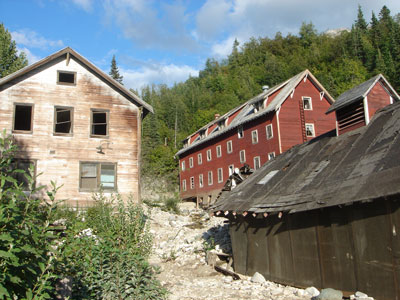
Kennecott
Historic mining settlement featuring preserved industrial buildings, abandoned structures, and access to glaciers and rugged wilderness landscapes.
Gerald Smith, Public domain, via Wikimedia Commons; Image Size Adjusted
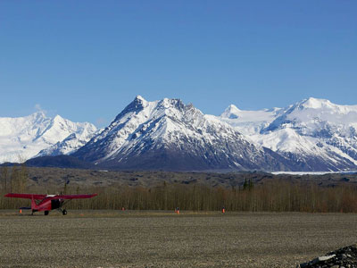
McCarthy, AK
Remote historic town offering rustic accommodations, preserved frontier-era buildings, and access to vast wilderness, glaciers, and outdoor exploration.
_(21587560302)-400.jpg)
National Park Service, Alaska Region, Public domain, via Wikimedia Commons; Image Size Adjusted
_(21587560302).jpg)
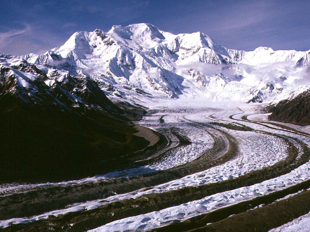
Root Glacier Trail
Moderately challenging trail traversing glacial moraine and rocky terrain to a vast ice field where visitors can step onto a dynamic glacier surrounded by mountain scenery.
-1000.jpg)
.jpg)