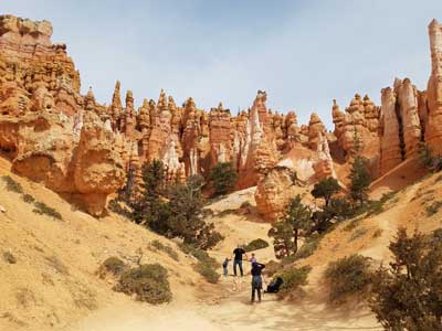
Travels by switchbacks down between narrow walls of colorful limestone with views of towering Douglas-fir trees and the park's most famous hoodoo: Thor's hammer
How to Get There
From Bryce Canyon City (4 mi): Travel south on UT-63 into Bryce Canyon National Park, continue past the visitor center along the main park road, and turn into the Sunset Point parking area where the Navajo Loop Trail begins.
The iconic Navajo Loop Trail begins and ends at Sunset Point, travelling by switchbacks down between narrow walls of colorful limestone with views of towering Douglas-fir trees and the park's most famous hoodoo: Thor's hammer. The loop has two sides, the Two Bridges side (0.6 miles [1 km]) and the Wall Street side 0.7 miles [1.1 km]. The Two Bridges side is open year-round, however the Wall Street side is closed in months when precipitation combines with freezing overnight temperatures. When both sides are open, we generally recommend this as a counter-clockwise loop. When Wall Street is closed, the Two Bridges side can be hiked as an out-and-back or combined with other trails.
One side of the Navajo Loop (Two Bridges when Wall Street is closed) is often combined with the Queen's Garden Trail to form the 2.9 mile (4.6 km) Queen's / Navajo Combination Loop. The Navajo Loop can also be combined with the Peekaboo Loop to form the 4.9 mile (7.8 km) Navajo / Peekaboo Combination or combine the Queen's / Navajo Combination Loop with the Peekaboo Loop to get the 6.4 mile (10.2 km) Figure-8 Combination.
This article uses material from nps.gov "Bryce Canyon National Park"