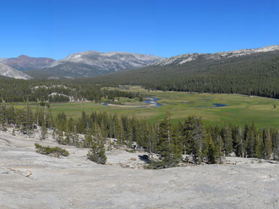

Gentle, dome-studded, sub-alpine meadow area along the Tuolumne River in the eastern section of park
How to Get There
From Yosemite Valley El Portal Entrance (57 mi): Take El Portal Rd and Big Oak Flat Rd to Ireland Lake. Follow Tioga Rd/Tioga Pass Rd to Tuolumne County. Drive to Tuolumne Meadow.
Overview
Tuolumne Meadows is a huge, gentle subalpine meadow at about 8,600 feet in Yosemite’s high country, along the Tuolumne River and surrounded by granite domes and peaks, and a base for hiking, climbing and camping away from the crowds of Yosemite Valley. Wildflowers bloom in summer, and views from the meadow include Lembert Dome, Unicorn Peak, the Cathedral Range and Mount Dana.
Popular trails include Cathedral Lakes, Gaylor Lakes, Mono Pass, Lembert Dome and the route to Mount Lyell, Yosemite’s highest peak, while the John Muir Trail and Pacific Crest Trail pass through Lyell Canyon. The Tuolumne Meadows Campground is popular and reservations are recommended. The area is accessible only when Tioga Road is open, generally late May or June to October.
This article uses material from the Wikipedia articles "California State Route 120" and "Tioga Pass" and "Tioga Pass Entrance Station", which are released under the Creative Commons Attribution-Share-Alike License 3.0


