Young volcanic cinder cone rising above a lava plain in the Mojave Desert, between Barstow and Needles, California
From Los Angeles (153 mi): Get on US-101 S. Follow I-10 E, I-15 N and I-40 E to Hector Rd in San Bernardino County. Take exit 33 from I-40 E. Take National Trails Hwy to Pisgah Crater Rd.
Overview
Pisgah Crater, or Pisgah Volcano, is a young volcanic cinder cone rising above a lava plain in the Mojave Desert, between Barstow and Needles, California. The volcanic peak is around 2.5 miles (4.0 km) south of historic U.S. Route 66-National Old Trails Highway and of Interstate 40, and west of the town of Ludlow. The volcano had a historic elevation of 2,638 feet (804 m), but has been reduced to 2,545 feet (776 m) due to mining.
History
The volcano was the site of the Mount Pisgah Volcanic Cinders Mine, a cinder quarry that produced pumice for commercial use, the primary end product being railroad ballast for the Santa Fe Railroad. The mountain is currently owned by Can-Cal Resources Limited, a Canadian company specializing in exploration of precious minerals in California.
Mining has had a severe environmental impact; the top of the mountain has been removed and the sides of this historically symmetrical mountain have been scoured into an irregular shape. The mountain is still occasionally quarried for various cinder products, and sand from the mountain was used to depict the black sands of Iwo Jima in the film Letters from Iwo Jima.
Geography
Currently, the crater stands 98 meters (321 feet) above the surrounding High Desert terrain, and has a base diameter of 488 meters (1,600 feet). It has lost much of its original cinder cone shape to ongoing aggregate mining operations, in addition to minor natural erosion.
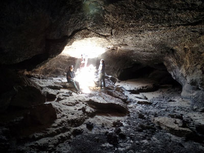
The mountain contains a large number of lava tubes, which are frequented by cavers. The most well known cave is the 1,300-foot (400 m)-long SPJ Cave.
Located in the Basin and Range Province, the Mojave Valley and then the Cady Mountains lie to the north of the peak, while the Rodman Mountains lie to the west. The Lava Bed Mountains lie to the south, and the Bullion Mountains lie to the southeast.
Recreation
The crater and much of the surrounding lava field are on private property. Despite this, the lava tubes in the area are a somewhat popular and easily accessible destination for caving. Historic Lavic Siding is to the east, with the Mojave National Preserve beyond.
This article uses material from the Wikipedia article "Pisgah Crater", which is released under the Creative Commons Attribution-Share-Alike License 3.0
-1000.jpg)
.JPG)