Volcanic island in the Aleutian Islands in Alaska with the city of Unalaska, Alaska, covering part of the island and all of neighboring Amaknak Island where the Port of Dutch Harbor is located
General Information
How to Get There
From Anchorage, AK (~800 mi): Fly Alaska Airlines to Unalaska/Dutch Harbor Airport (DUT) ~2.5 hours, then take a taxi or rental car to reach Unalaska's historic sites, restaurants, and waterfront.
Unalaska Island
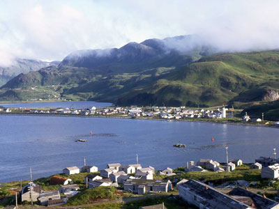
Unalaska is a volcanic island in the Fox Islands group of the Aleutian Islands in Alaska. The island has a land area of 1,051 square miles (2,720 km2). It measures 79.4 mi (127.8 km) long and 34.7 mi (55.8 km) wide. The city of Unalaska, Alaska, covers part of the island and all of neighboring Amaknak Island where the Port of Dutch Harbor is located.
Unalaska is the second-largest island in the Fox Islands group and the Aleutian Islands. The coastline of Unalaska is markedly different in appearance than other major Aleutian Islands, with numerous inlets and peninsulas. The irregular coastline is broken by three long deep bays, Beaver Inlet, Unalaska Bay, and Makushin Bay, as well as by numerous smaller bays and coves. Unalaska's terrain is rugged and covered with mountains, and during the greater part of the year, the higher elevations are covered with snow. The highest point on Unalaska is the active volcano Mount Makushin.
Unalaska is the Aleut name for the island. Several theories about its origin exist; the most likely is that the name derives from the Russian word Ounalashka, an adaptation of the Aleut word for near the mainland, nawan Alaskax.
Unalaska is the chief center of population in the Aleutian Islands. The Aleut (Unangan) people have lived on Unalaska Island for thousands of years. The Unangan, who were the first to inhabit the island of Unalaska, named it "Ounalashka", meaning "near the peninsula". The Russian fur trade reached Unalaska when Stepan Glotov and his crew arrived on August 1, 1759. Natives, Russians and their descendants comprised most of the community's population until the mid-20th century, when the involvement of the United States in World War II led to a large-scale influx of people and construction of buildings all along the strategically located Aleutians.
Almost all of the community's port facilities are on Amaknak Island, better known as Dutch Harbor or just "Dutch". It is the largest fisheries port in the U.S. by volume caught. It includes Dutch Harbor Naval Operating Base and Fort Mears, U.S. Army, a U.S. National Historic Landmark. Dutch Harbor lies within the city limits of Unalaska and is connected to Unalaska by a bridge. Amaknak Island is home to almost 59 percent of the city's population, although it has less than 3 percent of its land area.
As a result of the town's strong fishing industry, Unalaska has also become notable for its large population of bald eagles, which number in the hundreds and were attracted to the area by human activity.
Since 2005, the Discovery Channel's documentary show Deadliest Catch has focused on fishermen who are based in Dutch Harbor.
Makushin Volcano (5,691 ft/1,735 m) is located on the island; it is not quite visible from within the town of Unalaska, though the steam rising from its cone is visible on the rare clear day. By climbing one of the smaller hills in the area, such as Pyramid Peak or Mount Newhall, it is possible to get a good look at the snow-covered cone.
The state of Alaska owns a 4,500 by 100 ft (1,372 by 30 m) paved runway, where daily flights are scheduled. A seaplane base is also available.
The Alaska Marine Highway operates once every two weeks from Kodiak between April and October.
There are approximately seven miles (11 km) of paved road, and 38 miles (61 km) of road total in Unalaska.
This article uses material from the Wikipedia article "Unalaska Island", and "Unalaska, Alaska", which is released under the Creative Commons Attribution-Share-Alike License 3.0
Featured Locations and Trails

Jeff P from Berkeley, CA, USA, CC BY 2.0, via Wikimedia Commons; Image Size Adjusted
.jpg)
Church of the Holy Ascension
Prominent landmark in Unalaska, is one of the oldest churches in Alaska, and is significant as the site from which missionaries brought their religion to the local Aleut people