National Monument created to protect Mogollon cliff dwellings in the Gila Wilderness on the headwaters of the Gila River in southwest New Mexico
General Information
Visitor Center: 8am to 4:30pm
Closed Thanksgiving Day, Christmas Day, and New Year’s Day
How to Get There
From Silver City (45 mi): Take NM-15 north for about 44 miles to the monument; the drive is narrow and winding, taking roughly 1.5–2 hours.
``Overview
Gila Cliff Dwellings National Monument was created to protect Mogollon cliff dwellings in the Gila Wilderness on the headwaters of the Gila River in southwest New Mexico. The 533-acre (2.16 km2) national monument was established by President Theodore Roosevelt through executive proclamation on November 16, 1907. It is located in the extreme southern portion of Catron County. Visitors can access the monument by traveling northbound from Silver City, New Mexico, 45 miles (72 km) on NM 15.
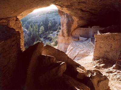
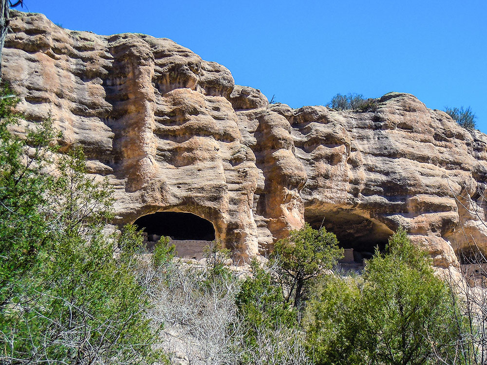
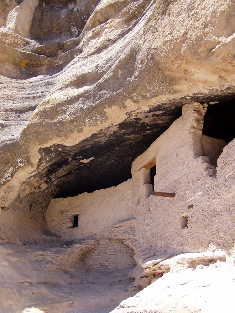
Considered by archaeologists to be on the northernmost portion of the Mogollon people's sphere of influence, the Gila Cliff Dwellings National Monument is home to two prominent ruins sites among a collection of smaller sites located within the Gila Wilderness inside the Gila National Forest. The landscape in the monument ranges in elevation from around 5,700 to 7,300 feet (1,700 to 2,200 m) above sea level and follows the West Fork and the Middle Fork of the Gila River. The terrain around the ruins is rugged and arid, and contains steep-sided canyons cut by shallow spring rivers and mesas and bluffs forested with Ponderosa pine, Gambel's oak, Douglas fir, New Mexico juniper, pinon pine, and alligator juniper (among others). The area geologic history stems from the Oligocene epoch and volcanic activity that subsequently covered the area with ash. The monument's hot springs are remnants of this volcanic history.
Explore the Cliff Dwellings
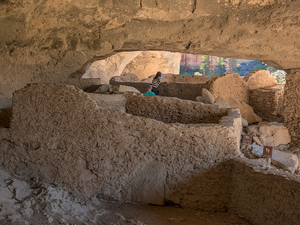
Walk through remarkably preserved cave homes built over 700 years ago by the Mogollon (Southern Ancestral Pueblo) people. You can enter several caves, climb ladders, and see how ancient families lived inside these cliffside shelters, making this one of the most immersive archaeological sites in the Southwest.
Hike the Cliff Dwellings Trail
A scenic ~1-mile loop trail takes you to the dwellings through a canyon landscape. The hike is considered easy to moderate, featuring rocky terrain, gradual elevation gain, and beautiful views of the canyon and surrounding forest.
Visit the Visitor Center and Museum
Stop at the visitor center to learn about the Mogollon culture, view artifacts such as pottery fragments, and get updates on trail conditions. It’s a great starting point for understanding the history and significance of the monument.
Go Hiking in the Surrounding Gila Wilderness
Beyond the main trail, the surrounding Gila Wilderness offers over 600 miles of hiking routes through forests, rivers, and rugged canyons. Popular trails include river routes and canyon loops that provide deeper exploration into the region’s wilderness and history.
Check Out Nearby Hot Springs
Not far from the monument, natural hot springs offer a relaxing experience surrounded by forested landscapes. These geothermal pools provide a unique way to unwind after hiking and exploring the area.
This article uses material from the official National Park Service pages for Gila Cliff Dwellings National Monument, as well as supporting travel and park resources including Plan Your Visit - Gila Cliff Dwellings National Monument, Backpacking in the Gila Wilderness, Western National Parks Association, Visiting Gila Cliff Dwellings National Monument, AllTrails Guide, and Top Things to Do at Gila Cliff Dwellings National Monument.
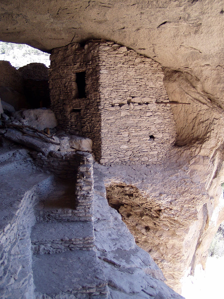
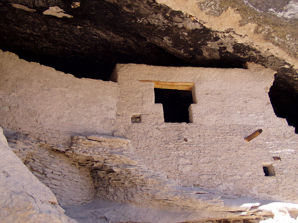
The monument consists of 553 acres (2.24 km2) and contains the remains of a Mimbres Culture community in various locations, two of which are most prominent. The namesake ruins' developers made use of natural caves to build interlinked dwellings within five cliff alcoves above Cliff Dweller Canyon. The TJ Ruins are located on a bluff overlooking the Gila River. The Mogollon peoples are believed to have inhabited the region from between 1275 and into the early 14th century, during the Pueblo III Era.
Archaeologists have identified 46 rooms in the five caves on Cliff Dweller Canyon, and believe they were occupied by 10 to 15 families. The "Heart-Bar Site" or the TJ Ruins (named for the former ranch from which the mesa takes its name) located on TJ Mesa are largely un-excavated. It is not known why the community was abandoned.
Hopi oral tradition refers to migrations occurred based cycles calendars, and in response to changing environmental conditions. Other ruins include Javalina House, about 1/3 mile above the main ruin, West Fork Ruin, currently under Highway 15 across from Woody Corral, Three Mile Ruin along the west fork of the Gila River, and middle fork of the Gila River at the 11-room Cosgrove Ruin. Dendrochronology (tree ring dating) determined that the wood used in the dwellings were cut between 1276 and 1287. The region provided for growing, gathering and hunting food.
To visit the namesake dwellings, visitors are required to hike a well-traveled 1-mile-long (1.6 km) trail loop with several foot bridges over a stream. The entire walk takes about an hour. The hike begins at an elevation of 5,695 feet (1,736 m) and ends at 5,875 feet (1,791 m).
A museum and visitor center is located at the monument near the TJ Ruins. The visitor center is jointly operated by the U.S. Forest Service and the National Park Service. The museum hosts exhibits of Apache and Mogollon artifacts, uncovered both in the surrounding wilderness and at the monument. Displayed items include a bracelet crafted from Glycymeris Bittersweet clam shells found by a student park ranger, Charles Grymko. Believed to have been brought via trade from the Gulf of California to Snaketown (an ancient village on the right bank of the Gila River on the modern-day Gila River Indian Community south of the village of Ahwatukee), the shell eventually was etched and drilled by Hohokam artisans. The bracelet is believed then to have made its way up the Gila River from Arizona to the Gila River community, again by way of trade.
This article uses material from the Wikipedia article "Gila Cliff Dwellings National Monument", which is released under the Creative Commons Attribution-Share-Alike License 3.0
Featured Trails
Placeholder, License, via Wikimedia Commons; Image Size Adjusted
Cliff Dwellings Trail
Difficulty: Easy to Moderate
Short scenic loop leading visitors into ancient cliff dwellings with canyon views along the way

Placeholder, License, via Wikimedia Commons; Image Size Adjusted
West Fork Gila River Trail
Difficulty: Moderate
River-side trail with multiple stream crossings through lush canyon scenery and wildlife habitat
Placeholder, License, via Wikimedia Commons; Image Size Adjusted
Little Bear Canyon Loop
Difficulty: Hard
Rugged wilderness loop featuring slot canyons, elevation changes, and diverse desert landscapes
-1000.jpg)
.jpg)