
How to Get There
From Taos (40 mi): Take US-64 E toward Eagle Nest and continue along the Enchanted Circle Scenic Byway until reaching the park entrance along the Cimarron Canyon.
Overview
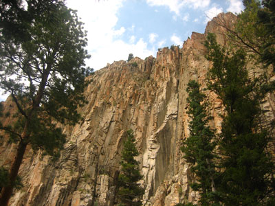
Cimarron Canyon State Park, three miles east of Eagle Nest on US 64, runs through a canyon of granite cliffs (the Palisades) along the Cimarron River in the Colin Neblett Wildlife Area. Its forests and meadows shelter elk, deer, and black bears. It is a scenic drive on the Enchanted Circle, with hiking in summer and snowshoeing in winter, and camping in three campgrounds along the river.
Top Trails
| Trail | Length | Difficulty | Highlights |
|---|---|---|---|
| Clear Creek Trail | About 3 miles round trip | Moderate | The park's most popular trail, through the canyon forest above the river |
| Kit Carson Trail | About 2 miles | Easy to moderate | Follows the river |
Camping
Cimarron Canyon State Park boasts three full campgrounds, which are located along the river between the villages of Eagle Nest and Ute Park. These include the Maverick, Tolby, and Ponderosa campgrounds, as well as Black Jack Tent Area. All three campgrounds offer numerous individual sites for RV or tent camping.
This article uses material from the Wikipedia article "Cimarron Canyon State Park", which is released under the Creative Commons Attribution-Share-Alike License 3.0