-400.jpg)
.jpg)
Monument is located in southwestern Colorado between Cortez, Colorado and Blanding, Utah, largely known for the six groups of Ancestral Puebloan villages
General Information
May–September: 8:00am – 6:00pm
October & April: 8:00am – 5:00pm
November–March: 9:00am – 5:00pm
Trails open sunrise to sunset; closed Thanksgiving, Christmas, and New Year’s Day
Motorcycle: $15
Per Person (walk/bike): $10
Children under 16: Free
Blanding (45 mi)
Monticello (50 mi)
How to Get There
From Cortez (42 mi): Take US-491 south briefly, turn onto County Road G (McElmo Canyon Road) and follow it west, then connect to County Roads 401 and 413 to reach the monument entrance and visitor center.
Overview
Hovenweep National Monument is located on land in southwestern Colorado and southeastern Utah, between Cortez, Colorado and Blanding, Utah on the Cajon Mesa of the Great Sage Plain. Shallow tributaries run through the wide and deep canyons into the San Juan River.
Although Hovenweep National Monument is largely known for the six groups of Ancestral Puebloan villages, there is evidence of occupation by hunter-gatherers from 8,000 to 6,000 B.C. until about AD 200. Later, a succession of early puebloan cultures settled in the area and remained until the 14th century.
Things to Do
Explore Ancient Towers and Villages of the Four Corners Region
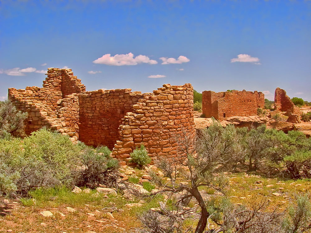
Hovenweep National Monument preserves a remarkable collection of ancestral Puebloan villages, towers, ceremonial structures, and archaeological sites spread across the remote canyon country of southwestern Colorado and southeastern Utah. Built between approximately A.D. 1200 and 1300, these communities showcase the engineering, architecture, and agricultural skills of the ancestral Pueblo people who thrived in the Four Corners region for centuries.
Visit the Monument's Ancient Tower Complexes
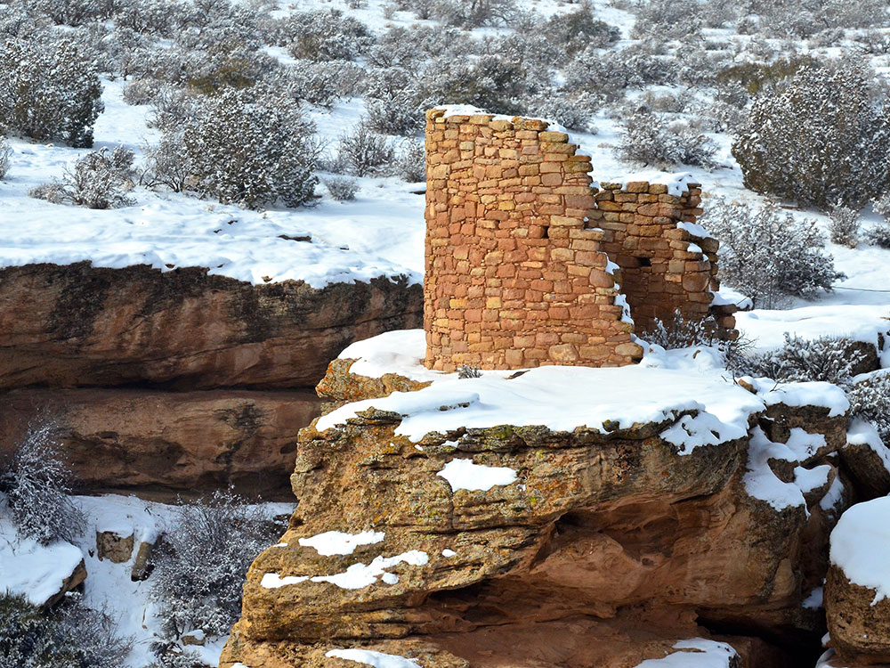
Hovenweep is famous for its distinctive stone towers, many of which were constructed along canyon rims, boulders, and cliff edges. These impressive structures remain among the best-preserved examples of ancestral Puebloan architecture and continue to inspire archaeologists and visitors alike.
Explore Square Tower Group
The Square Tower Group is the monument's largest and most accessible archaeological area. Visitors can view multi-story towers, kivas, room blocks, check dams, and other structures that overlook Little Ruin Canyon. Interpretive exhibits explain the history and significance of the site.
Learn About Ancestral Puebloan Life
The monument offers insight into farming, water management, astronomy, trade, and community life in an arid environment. Visitors can learn how ancestral Pueblo people adapted to challenging conditions while creating thriving settlements throughout the region.
Experience Dark Skies and Remote Desert Landscapes
Hovenweep is designated as an International Dark Sky Park and is one of the best places in the Southwest for stargazing. The monument's remote location provides exceptional opportunities to view the Milky Way, constellations, and meteor showers while enjoying peaceful desert scenery.
Top Trails
Square Tower Group Trail
Length: Approximately 2 miles loop
Elevation Gain: Moderate
Difficulty: Easy to Moderate
This signature trail circles Little Ruin Canyon and passes many of the monument's most famous archaeological features, including Square Tower, Hovenweep Castle, Twin Towers, and several kivas. Numerous overlooks provide outstanding views of both the ruins and canyon landscape.
Holly Group Trail
Length: Approximately 2 miles round trip
Elevation Gain: Moderate
Difficulty: Moderate
This trail leads to the Holly Group, a collection of towers and room blocks situated along canyon walls. Visitors can observe impressive masonry and unique architectural features while enjoying a quieter experience away from the main visitor area.
Cutthroat Castle Trail
Length: Approximately 1 mile round trip
Elevation Gain: Moderate
Difficulty: Moderate
This short route provides access to one of Hovenweep's outlying village sites. The trail offers views of well-preserved masonry structures and opportunities to learn about the monument's dispersed settlements.
Cajon and Horseshoe Unit Trails
Length: Variable distances available
Elevation Gain: Minimal to Moderate
Difficulty: Easy to Moderate
These remote trails lead to smaller archaeological groups featuring towers, pueblos, and canyon viewpoints. They provide opportunities for solitude, photography, and exploration of lesser-visited areas within the monument.
Sources: National Park Service official Hovenweep National Monument information, including details on Square Tower Group, ancestral Puebloan villages, archaeological resources, hiking trails, dark sky programs, and visitor experiences. https://www.nps.gov/hove
Additional information verified through National Park Service visitor resources covering Holly Group, Cutthroat Castle, Cajon Unit, Horseshoe Unit, cultural history, and recreational opportunities throughout Hovenweep National Monument.
Hovenweep became a National Monument in 1923 and is administered by the National Park Service. In July 2014, the International Dark-Sky Association designated Hovenweep an International Dark Sky Park.
In 1854, William D. Huntington, on a missionary trip to the southwestern United States for Brigham Young, discovered the ruins of the present Hovenweep National Monument. The ruins were already known to the Ute and Navajo guides who considered them haunted and urged Huntington to stay away.
The name Hovenweep, which means "deserted valley" in the Ute language, was adopted by pioneer photographer William Henry Jackson and William Henry Holmes in 1878. The name is apt as a description of the area's desolate canyons and barren mesas as well as the ruins of ancient communities.
This article uses material from the Wikipedia article "Hovenweep National Monument", which is released under the Creative Commons Attribution-Share-Alike License 3.0
-1000.jpg)
.jpg)
-1000.jpg)
.jpg)