Monument featuring sheer-walled canyons cut deep into sandstone and granite-gneiss-schist rock formations
Visitor Center hours:
Standard visitor center hours are 9:00 a.m. to 4:30 p.m. with extended hours in the summer (8:00 a.m. to 6:00 p.m.)
The visitor center is closed Thanksgiving, Christmas, and New Year's Day.
Admission to Arches National Park is good for seven days
Accepts America The Beautiful Pass
From Grand Junction: Head north on S 13th St toward Ute Ave. Turn left onto Ute Ave. Ute Ave turns slightly right and becomes S 1st St. Turn left onto W Grand Ave. Continue onto Broadway. Turn left onto Monument Rd.
Overview
Colorado National Monument is a National Park Service unit near the city of Grand Junction, Colorado. Sheer-walled canyons cut deep into sandstone and granite-gneiss-schist rock formations. This is an area of desert land high on the Colorado Plateau, with pinyon and juniper forests on the plateau. The park hosts a wide range of wildlife, including red-tailed hawks, golden eagles, ravens, jays, desert bighorn sheep, and coyotes. Activities include hiking, horseback riding, road bicycling, and scenic drives; a visitor center on the west side contains a natural history museum and gift shop. There are scenic views from trails, Rim Rock Drive, which winds along the plateau, and the campground. Nearby are the Book Cliffs and the largest flat-topped mountain in the world, the Grand Mesa.
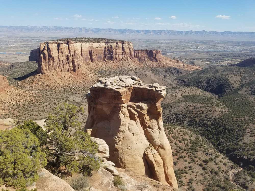
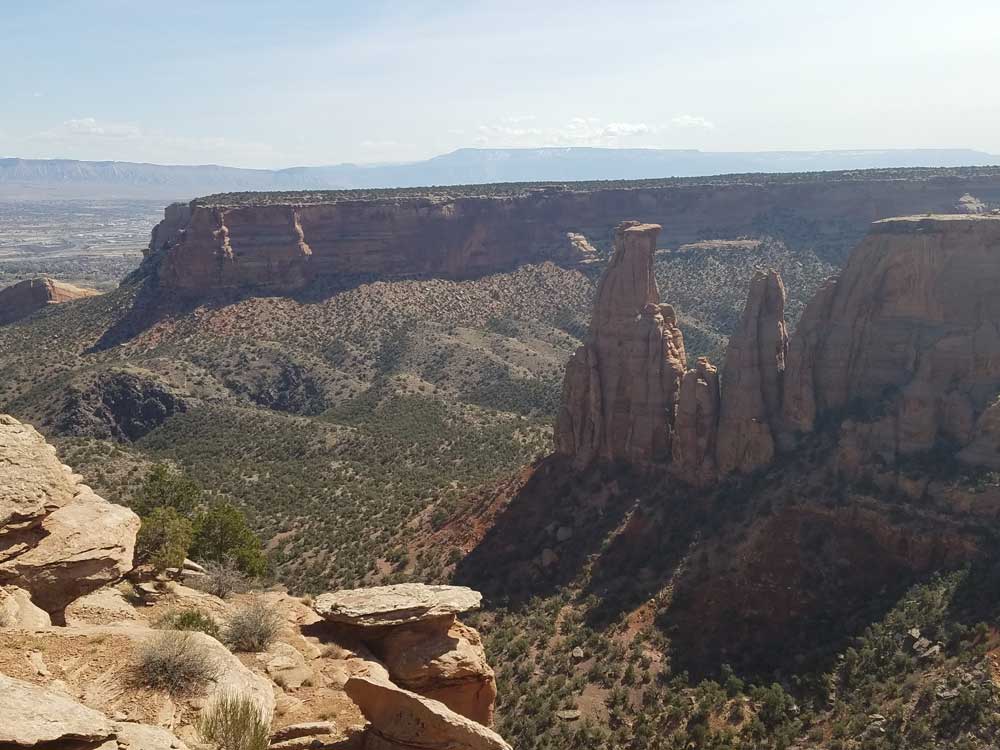
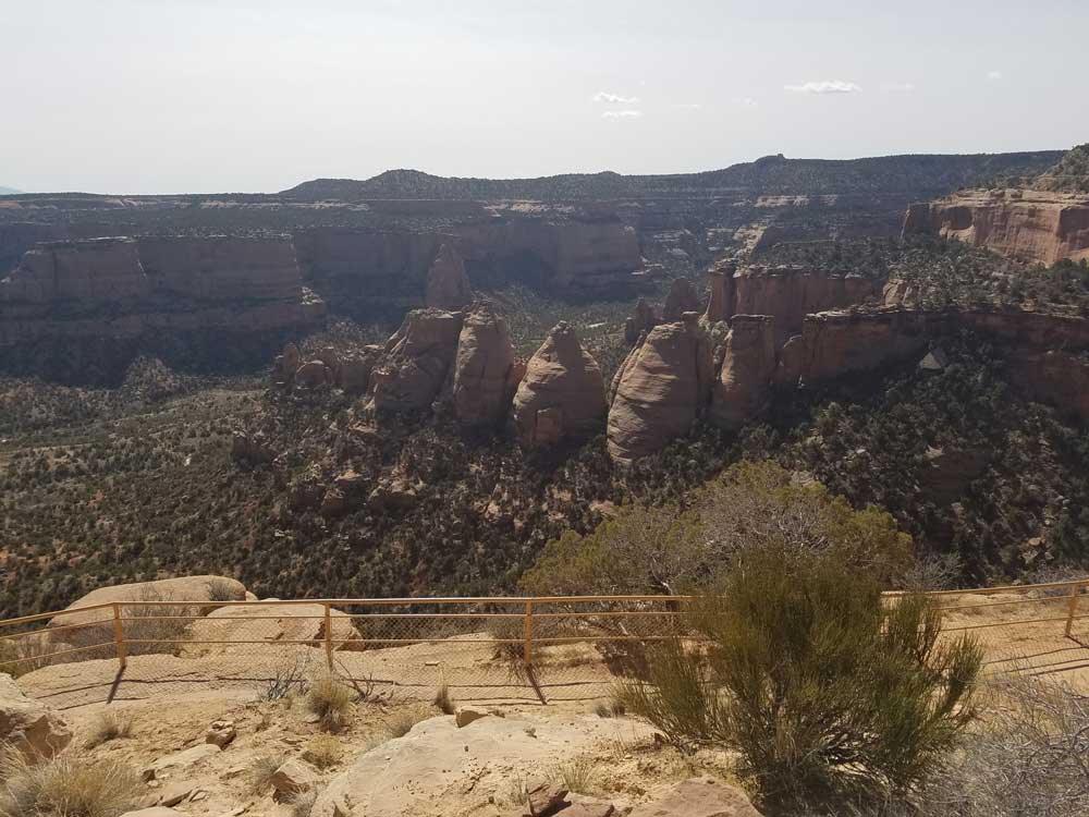
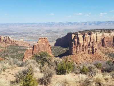
The monument's feature attraction is Monument Canyon, which runs the width of the park and includes rock formations such as Independence Monument, the Kissing Couple, and Coke Ovens. The monument includes 20,500 acres (32.0 sq mi; 83 km2), much of which has been recommended to Congress for designation as wilderness.
Things to Do
Discover Colorado's Canyon Country on the Edge of the Rockies
Colorado National Monument protects more than 20,000 acres of spectacular red rock canyons, towering sandstone monoliths, sheer cliff walls, and high desert landscapes near Grand Junction in western Colorado. Established in 1911, the monument showcases some of the most dramatic scenery in the American Southwest and provides visitors with exceptional opportunities for hiking, scenic driving, photography, wildlife viewing, and outdoor adventure.
Drive the Rim Rock Drive Scenic Road
One of the monument's most famous attractions is Rim Rock Drive, a 23-mile scenic roadway that winds along canyon rims and through tunnels blasted into the rock. Numerous overlooks provide breathtaking views of deep canyons, towering formations, and the Grand Valley below. The drive is widely regarded as one of the most scenic roads in the United States.
See Iconic Rock Formations
The monument contains many striking geological landmarks, including Independence Monument, Kissing Couple, Coke Ovens, Sentinel Spire, and Pipe Organ. These towering rock formations create a dramatic landscape that is especially beautiful at sunrise and sunset.
Enjoy Wildlife Viewing
Colorado National Monument supports a variety of wildlife, including desert bighorn sheep, mule deer, coyotes, golden eagles, red-tailed hawks, ravens, and numerous desert-adapted species. Wildlife can often be observed from scenic overlooks and hiking trails throughout the monument.
Experience the High Desert Ecosystem
Visitors can explore pinyon-juniper woodlands, desert shrublands, and rugged canyon environments while learning about the unique plants and animals that thrive in western Colorado's semi-arid climate.
Top Trails
Serpents Trail
Length: Approximately 2.5 miles one way
Elevation Gain: About 1,000 feet
Difficulty: Moderate to Strenuous
This historic trail climbs from the monument entrance to the canyon rim through a series of switchbacks. The route rewards hikers with outstanding views of the surrounding canyons, cliffs, and Grand Valley.
Devils Kitchen Trail
Length: Approximately 2 miles round trip
Elevation Gain: Moderate
Difficulty: Moderate
One of the monument's most popular hikes, this trail leads to a unique enclosed sandstone grotto surrounded by colorful rock formations. The route features canyon scenery, rock walls, and excellent photography opportunities.
Monument Canyon Trail
Length: Approximately 6 miles one way
Elevation Gain: Moderate
Difficulty: Strenuous
This signature backcountry trail passes many of the monument's most famous formations, including Independence Monument. Hikers experience dramatic canyon scenery, towering sandstone walls, and sweeping desert vistas.
Otto's Trail
Length: Approximately 1 mile round trip
Elevation Gain: Minimal
Difficulty: Easy
A short family-friendly trail leading to panoramic overlooks of Monument Canyon. The route provides some of the monument's most accessible and rewarding views.
Sources: National Park Service official Colorado National Monument information, including details on Rim Rock Drive, Monument Canyon, hiking trails, wildlife viewing, geology, and visitor experiences. https://www.nps.gov/colm
Additional information verified through National Park Service visitor resources covering Serpents Trail, Devils Kitchen Trail, Otto's Trail, Independence Monument, scenic overlooks, and recreational opportunities throughout Colorado National Monument. https://www.nps.gov/colm/planyourvisit
Trails
The Monument contains many hiking trails, with lengths and difficulties to suit all tastes. Summer storms can cause flash floods as well as dangerous trail conditions. Rattlesnakes are found on the Monument, and rough terrain exists everywhere, but most trails are well-maintained. Winter cross-country skiing is occasionally possible on trails such as the Liberty Cap Trail.
Serpents Trail, perhaps the most popular, follows the route of the original road to the top of the Monument. This trail is accessible by parking lots at both ends, both located off Rim Rock Drive. Serpents Trail is well-maintained and provides stunning views of both the Monument itself and the Grand Valley below. One of the shortest trails, also popular, is Devil's Kitchen. The trailhead is located near the eastern entrance of the park on Rim Rock Drive. This trail is about 1 mile long, and ends in a sandstone grotto. Devil's Kitchen trail is well suited for families with smaller children, as the hike is short and the "kitchen" itself provides plenty of opportunity for child-sized exploration.
Liberty Cap trail starts from the valley floor and climbs to the rim of the Monument. Liberty Cap itself is an ancient sand dune, and provides a beautiful view of the Grand Valley. Corkscrew Trail, closed for many years but re-opened in mid-2006, branches off the Liberty Cap and skirts a small canyon and cliffs that cannot be seen from the valley floor. This trail, the only loop trail on the Monument, is about 3 miles long and features a less rigorous climb than Liberty Cap.
Monument Canyon trail, also popular, follows Monument Canyon for about 5 miles. This trail is often hiked up-and-back, and provides close-up views of Independence Monument, the Colorado National Monument's most distinct feature, as well as a formation named Kissing Couple. The lower trailhead is accessible from CO 340 (Broadway).
No Thoroughfare Trail starts at the bottom of No Thoroughfare Canyon, near the east entrance. As the name implies, there is no official trail to the top of this canyon. The dead-end trail goes a few miles into the canyon, and up-and-back hiking is required. Some hikers have found a way to get through the entire canyon, but after a certain point the trail becomes difficult and unmarked. No Thoroughfare Canyon does have small waterfalls during the spring run-off, but is dry for most of the year.
Many of the early visitor facilities at Colorado National Monument were designed by the National Park Service and constructed by the Public Works Administration and the Civilian Conservation Corps. Several of these areas have been placed on the National Register of Historic Places in recognition of this and in consequence of their adherence to the National Park Service Rustic design standards of the time. The entire Rim Rock Drive is a National Historic District, as well as the Serpents Trail, the Devils Kitchen Picnic Shelter, and three places in the Saddlehorn area: the Saddlehorn Caretaker's House and Garage, Saddlehorn Comfort Station, and the Saddlehorn Utility Area Historic District. The Visitor Center complex is also included as an example of the Mission 66 program.
The park's geologic record preserves three different groups of rock and sediment. The oldest rocks are Early to Middle Proterozoic gneiss and schist, including the Ute Canyon Stock. Overlying these, and separated by an angular unconformity, are mostly horizontally bedded Mesozoic sedimentary rocks, including the cliff-forming Wingate Sandstone. Overlying these are various types of Quaternary unconsolidated deposits such as alluvium, colluvium, and dunes. The sedimentary rocks are folded into monoclines by several faults, including the Redlands Thrust Fault.
This article uses material from the Wikipedia article "Colorado National Monument", which is released under the Creative Commons Attribution-Share-Alike License 3.0