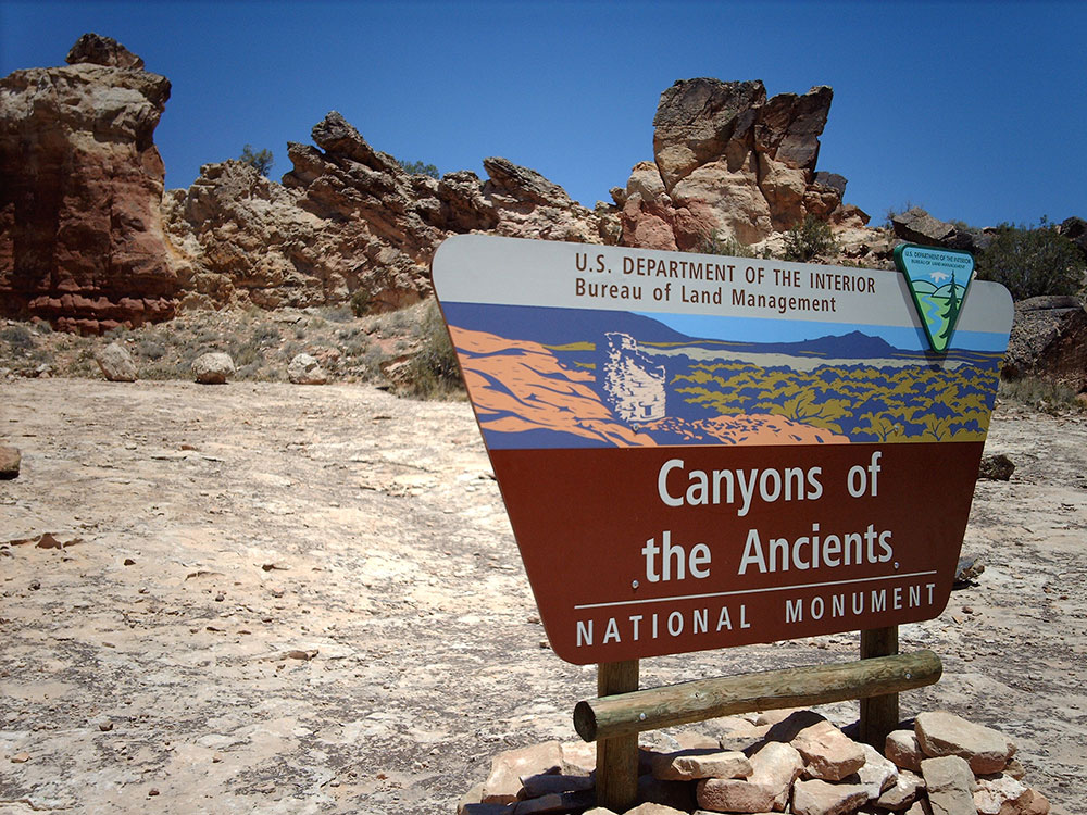
National monument protecting an archaeologically-significant landscape located in the southwestern region of Colorado
From Durango (47 mi): Take W 11th St to Camino Del Rio. Follow US-160 W to CO-184 W/N Main St in Mancos. Follow CO-184 W to destination.
Overview
Canyons of the Ancients National Monument is a national monument protecting an archaeologically-significant landscape located in the southwestern region of Colorado. The monument's 176,056 acres (71,247 ha) are managed by the Bureau of Land Management. Canyons of the Ancients encompasses and surrounds three of the four separate sections of Hovenweep National Monument, which is administered by the National Park Service. The monument was proclaimed in order to preserve the largest concentration of archaeological sites in the United States, primarily Ancestral Puebloan ruins. As of 2005, over 6,000 individual archeological sites had been identified within the monument.
Things to Do
Explore One of North America's Richest Archaeological Landscapes
Canyons of the Ancients National Monument protects more than 176,000 acres of high desert, mesas, canyons, and archaeological sites in southwestern Colorado. Managed by the Bureau of Land Management, the monument contains the highest known density of archaeological resources in the United States, with thousands of documented sites preserving the legacy of Ancestral Puebloan cultures and other Indigenous peoples who inhabited the region for thousands of years.
Visit the Canyons of the Ancients Visitor Center and Museum
The visitor center, located in Dolores, serves as the primary gateway to the monument. Exhibits feature ancient artifacts, cultural history displays, archaeological findings, and educational programs that help visitors understand the significance of the region's Indigenous heritage and prehistoric settlements.
Explore Ancient Pueblo Sites
The monument contains numerous archaeological sites, including cliff dwellings, masonry towers, kivas, rock art panels, field houses, and villages. Visitors can discover evidence of Ancestral Puebloan life while learning about agriculture, trade, community organization, and cultural traditions that flourished across the Four Corners region.
Visit Lowry Pueblo National Historic Landmark
Lowry Pueblo is one of the monument's most accessible and well-preserved archaeological sites. Visitors can view a reconstructed kiva, multi-room pueblo structures, and interpretive exhibits that provide insight into daily life more than 800 years ago.
Enjoy Scenic Desert Landscapes and Wildlife Viewing
The monument's rugged terrain includes sandstone canyons, piñon-juniper woodlands, sagebrush habitats, and expansive mesas. Wildlife commonly observed includes mule deer, coyotes, foxes, golden eagles, hawks, songbirds, and a variety of reptiles adapted to the desert environment.
Top Trails
Lowry Pueblo Trail
Length: Approximately 0.5 miles
Elevation Gain: Minimal
Difficulty: Easy
This short interpretive trail explores the Lowry Pueblo complex and provides educational information about the architecture, cultural significance, and history of one of the monument's premier archaeological sites.
Painted Hand Pueblo Trail
Length: Approximately 1 mile round trip
Elevation Gain: Moderate
Difficulty: Moderate
This trail leads to a remote archaeological site featuring preserved masonry structures and rock art. Visitors experience both cultural history and beautiful desert scenery while exploring the monument's backcountry.
Sand Canyon Trail
Length: Approximately 6.5 miles one way
Elevation Gain: Moderate
Difficulty: Moderate
One of the monument's premier hiking routes, Sand Canyon passes numerous archaeological features, canyon walls, and scenic overlooks. Hikers encounter cliff dwellings, ancient structures, and dramatic landscapes throughout the journey.
Sutcliffe Vineyards and McElmo Canyon Area Routes
Length: Variable distances available
Elevation Gain: Minimal to Moderate
Difficulty: Easy to Moderate
Additional routes throughout the monument provide access to cultural sites, scenic canyon viewpoints, and opportunities to explore the diverse natural and archaeological resources of southwestern Colorado.
Sources: Bureau of Land Management official Canyons of the Ancients National Monument information, including details on archaeological resources, Lowry Pueblo, visitor center exhibits, hiking opportunities, and cultural preservation. https://www.blm.gov/programs/national-conservation-lands/colorado/canyons-of-the-ancients
Additional information verified through Canyons of the Ancients Visitor Center and Museum resources covering Sand Canyon Trail, Painted Hand Pueblo, Ancestral Puebloan history, archaeological sites, and recreational opportunities throughout the monument.
Geography
Canyons of the Ancients National Monument is located 9 miles west of Pleasant View, Colorado in southwestern Colorado. The monument's northern and eastern boundaries are canyons. Its western boundary is the Colorado-Utah state border. Lands south are bordered by the Ute Mountain Reservation and McElmo Creek.
Canyons of the Ancients Visitor Center and Museum / Anasazi Heritage Center
The Canyons of the Ancients Visitor Center and Museum (formerly the Anasazi Heritage Center), located in Dolores, Colorado, is an archaeological museum of Native American pueblo and hunter-gatherer cultures. Two 12th-century archaeological sites, the Escalante and Dominguez Pueblos, at the center were once home to Ancient Pueblo peoples. The museum's permanent and special exhibits display some of the 3 million mostly Ancestral Puebloan artifacts curated at the facility. The center also houses a public research library, educational resources and a museum shop. Wheelchair-accessible facilities include a picnic area and an interpreted nature and cultural trail.
Ancient Pueblo People
Ancestral Puebloan people resided in permanent communities called pueblos and grew their own crops, in addition to hunting and gathering. The Ancient Pueblo people may have lived in the Four Corners area as early as 1500 BC. As many as 20,000 - 30,000 people lived and farmed in the Montezuma County, Colorado area. Each person required about one acre of land for up to 40 harvested bushels of corn per year. Other sources of food were obtained through hunting wild game and gathering wild plants, like berries and piñon nuts, growth of beans and squash and hunting. The area was affected by periods of drought, including one in the late 13th century. That and other factors resulted in the permanent move by 1300 AD of area pueblo people south to present-day New Mexico and Arizona. Anasazi, a term commonly attributed to ancient pueblo people, has been used since its first archaeological publication in the 1930s. The Navajo word does not represent specific tribes but means ancient enemy or outsider. The term is disliked by the modern Pueblo people who hold their ancient ancestors sacred and celebrated through spiritual rituals and journeys.
Escalante and Dominguez Pueblos
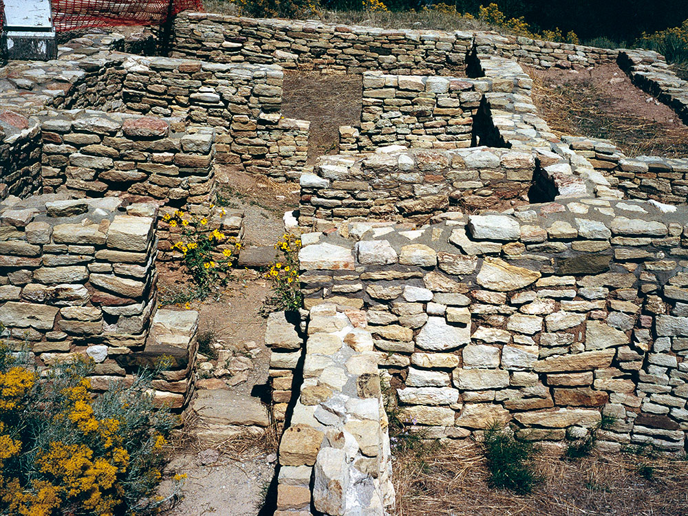
The Escalante and Dominguez Pueblos, located next to the Visitor Center and Museum, were homes of Ancestral Pueblo people three times. Escalante Pueblo was constructed approximately 1120 to 1130 AD and made of groupings of stone walled family and communal rooms, including kivas. The architecture is like that of the Chaco Canyon in present-day New Mexico. The pueblo was also occupied about 1150 AD and again 1200 AD.
Near the Escalante Pueblo is another small prehistoric household called Dominguez Pueblo, an example of independent family homes outside the main pueblo. Discovered at the site were items that shed light on how the people may have lived, including "6,900 turquoise, jet and shell beads; a shell and turquoise frog pendant and mosaics, two fine ceramic vessels, six bone scrapers, a woven mat and many other items."
The two interpreted prehistoric pueblos on the grounds of the Visitor Center and Museum are named in honor of the two Spanish Franciscan friars, Francisco Atanasio Domínguez and Silvestre Vélez de Escalante, who recorded these ancient archaeological sites during the Domínguez-Escalante expedition in 1776.
History
Developmental Pueblo: AD 750 to 1100
Ancient Pueblo people lived in the Canyons of the Ancients in the 10th century; Lowry Pueblo, built during the Great Pueblo period, was built atop pit-house built in the 10th century.
For a fuller understanding of the architecture and life style during this period, pueblo buildings in the Mesa Verde region were built with stone, windows facing south, and in U, E and L shapes. The buildings were located more closely together and reflected deepening religious celebration. Towers were built near kivas and likely used for look-outs. Pottery became more versatile, including pitchers, ladles, bowls, jars and tableware for food and drink. White pottery with black designs emerged, the pigments coming from plants. Water management and conservation techniques, including the use of reservoirs and silt-retaining dams also emerged during this period.
Great Pueblo period: AD 1100 to 1300
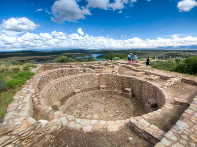
As refinements in construction techniques increased, the Puebloans built larger pueblos, or villages, on top of the pit-houses starting about AD 1090. Lowry Pueblo had just a few rooms and 2 kivas in 1090 and the village was expanded two times about 1103 and 1120 until it had 40 rooms, 8 kivas and one great kiva.
Like their ancient neighbors at Hovenweep National Monument and Mesa Verde National Park, the Lowry Pueblo dwellers were farmers and hunters. They grew beans, corn and squash and raised turkeys. They also made and decorated pottery.
Notable sites
At least 6,000 distinct structures have been identified in the monument, and the density of archeological remains is the highest of any region in the United States. The vast majority of stone structures in the national monument are from the Ancient Puebloans era.
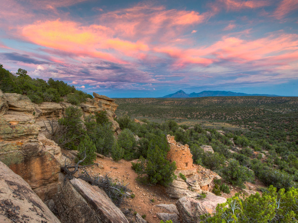
More than 20,000 sites have been identified, in some places more than 100 sites per square mile. After building basic pit style structures at first, the Puebloans later built villages with cliff dwellings. Archaeological ruins also include Sweat lodges, kivas, shrines and petroglyphs. Reservoirs with stone and earthen dams, including spillways and also numerous check dams, built in case of flash floods. Stone towers which may have been lookout or sentry posts, are found scattered throughout the monument.
Painted Hand Pueblo
The Painted Hand Pueblo is a backcountry site that consists of non-excavated ruins built upon boulders along a cliff-face and a standing tower. The pueblo received its name from a boulder with pictographs of hands.
Sand Canyon Pueblo
One of the largest pueblos of the 13th century, Sand Canyon Pueblo, built between 1250 and 1280, contains at least 20 multi-family room blocks with 420 rooms, 90 kivas, and 14 towers. A spring runs through the center of the walled site that held up to 725 people. Construction was exacting, with care taken to shape stone, and some double and triple walls for stability. Families lived in clusters of rooms that included living, storage and work rooms and had their own family kivas. The community shared roofed plazas and great kivas, and towers often connected to kivas. By 1280, new construction had stopped and people began migrating out of the pueblo.
Migration
Unlike other Ancient Pueblo site abandonment, it appears that the people of the Canyons of the Ancients left the sites much earlier than their neighbors, some time in the mid-12th century. Some of the artifacts found from the site show a connection to the Chacoan culture, while others are similar to those of the Mesa Verde dwellers.
Other Ancient Pueblo people from the area migrated south to Arizona and New Mexico, ancestors to modern pueblo people such as the Hopi and Zuni. Modern Pueblo people are located on reservations primarily in New Mexico, but some in Arizona. The 60,000 people's pueblos and reservations reside in three geographic areas:
- Along the upper Rio Grande in New Mexico, such as Taos Pueblo
- Southern New Mexican Zuni, Acoma, Laguna and Isleta pueblos and reservations
- Arizona Hopi.
Post-Pueblo Native American tribes: 14th to 18th century
After 1300, hunter-gatherers, ancestors of the Ute and Navajo, moved into the southwestern Colorado and southeastern Utah and came to inhabit the region.
The ancestors to the Navajo were one of the tribes of the southern division of the Athabaskan language family that migrated south from Alaska and northwestern Canada, most likely traveling through the Great Basin. The Navajo ancestors were in the area after AD 1300, but at least by the early 16th century.
The people from who the Ute descended arrived in the area from the west in this period from 1300 to the 18th century. The Ute's ancestors are hunter-gatherers who, in the 12th century, began migrating east from the present southern California area into a large hunter-gathering territory as far east as the Great Plains and in the canyons and mountains of eastern Utah and Colorado.
During this period, the Spanish colonial reach extended to northern New Mexico, where they settled in the 16th century. They introduced items for trade, such as guns and horses, new and deadly diseases, and cultural influence in the forms of religion, language, and forms of government. In the 18th century, Spanish missionaries visited the area looking for a route to Spanish missions in California. One of the expeditions was that of Spanish friars Silvestre Vélez de Escalante and Francisco Atanasio Domínguez who traveled from New Mexico, through western Colorado to Utah.
European and American settlement: 19th century to present
The first Anglo American people arrived in the early 19th century, starting with trappers. With the discovery of precious ores in the last decades of the 19th Century, miners and other settlers moved into the region. By the mid-19th century, the United States government and Native American tribes were at war over land ownership. The Navajo had moved south and the Ute territory was significantly reduced.
Excavation and restoration
Lowry Pueblo was excavated in 1928 and went through a restoration process in 1965. Two years later, it was named a National Historic Landmark and was listed on the National Register of Historic places.
National monument
The U.S. Bureau of Land Management administers the monument and enforces regulations balancing resource protection with land conservation. Facilities at the Lowry Pueblo include parking, a picnic area, toilet and trail. Sand Canyon Pueblo also has a trail, which leads to McElmo Canyon.
Wilderness study areas
Cahone Canyon, located about 4 miles southwest of the town of Cahone, Colorado, is about 9,156 acres. The wilderness area, varying from 5,900 to 6,000 feet (1,800 to 1,800 m) in elevation, consists of three canyons with piñon-juniper woodlands and riparian and sagebrush ecosystems.
Cross Canyon, located south of Cahone Canyon, about 14 miles southwest of the town of Cahone, Colorado, is about 12,721 acres, 1,008 acres cross into Utah. The wilderness area, varying from 5,140 to 6,500 feet (1,570 to 1,980 m) in elevation, consists of three canyons (Cross, Ruin, and Cow), with piñon-juniper woodlands and riparian and sagebrush ecosystems.
Cross Canyon, located south of Cahone Canyon, about 14 miles southwest of the town of Cahone, Colorado, is about 12,721 acres, 1,008 acres cross into Utah. The wilderness area, varying from 5,140 to 6,500 feet (1,570 to 1,980 m) in elevation, consists of three canyons (Cross, Ruin, and Cow), with piñon-juniper woodlands and riparian and sagebrush ecosystems.
The Anasazi Heritage Center
The Anasazi Heritage Center is also the visitor center for the Canyons of the Ancients National Monument and includes artifacts from the monument, a museum with interactive exhibits, a library and a theatre. Information is available there regarding the Ancient Puebloan culture, Trail of the Ancients Byway and the Canyons of the Ancients National Monument.
Wildlife
The Monument is home to a wide variety of desert wildlife, some of which are the American kestrels, Gambel's quail, Golden eagles, Long-Nosed Leopard lizard, Mesa Verde nightsnake, mourning dove, Peregrine falcons, Red-tailed hawks the Twin-spotted Spiny Lizard. Mammals that pass through the riparian and piñon-juniper woodland are jackrabbits, Mule deer, ringtail, fox, muskrat, beaver and bobcat.
This article uses material from the Wikipedia article "Canyons of the Ancients National Monument", and "Anasazi Heritage Center", which is released under the Creative Commons Attribution-Share-Alike License 3.0