-400.jpg)
All-American Road and a component in the Colorado Scenic and Historic Byway System, forms a 233.0-mile (375.0 km) loop in the southwest part of Colorado traversing the heart of the San Juan Mountains
From Grand Juction to Ouray (96 mi): Follow I-70BL E and 29 Rd to US-50 E in Orchard Mesa. Use any lane to turn left onto US-50 E. Continue on G50 Rd. Take G Rd to US-50 E/S Main St in Delta. Follow US-50 E to US-550 S in Ouray.
San Juan Skyway
The San Juan Skyway is an All-American Road and a component in the Colorado Scenic and Historic Byway System. It forms a 233.0-mile (375.0 km) loop in the southwest part of Colorado traversing the heart of the San Juan Mountains. It roughly parallels the routes of the narrow gauge railways: Rio Grande Southern (US 160, SH 145 and SH 62); and the unconnected Ouray and Silverton Branches of the Denver & Rio Grande along US 550 with the Silverton Railroad bridging a part of the gap. Its origin can be traced to the Around the Circle Route promoted by the D&RG.
U.S. Highway 160
Starting in Durango, Colorado, the largest city on San Juan Skyway, the byway follows U.S. Highway 160 (US 160) west through the town of Mancos to Cortez passing the entrance to Mesa Verde National Park.
State Highway 145
The byway turns north at Cortez, following State Highway 145 (SH 145) through the town of Dolores and the Dolores River into the San Juan National Forest. The byway passes through Rico, county seat of Dolores County prior to 1941. The old Courthouse still remains. From Rico the byway crosses 10,222 ft (3116 m) Lizard Head Pass and enters the Uncompahgre National Forest. Lizard Head Pass provides views of the 14,159-foot (4,316 m) El Diente Peak, the 14,246-foot (4,342 m) Mount Wilson, the 14,017-foot (4,272 m) Wilson Peak and the pass's namesake, the 13,113-foot (3,997 m) Lizard Head Peak. The byway descends near the town of Ophir past the location of the Ophir Loop of the Rio Grande Southern Railroad. A spur road heads off to the mining town turned ski resort of Telluride. The byway follows the San Miguel River to the town of Placerville.
State Highway 62
The byway turns east at Placerville onto SH 62 and follows it over Dallas Divide. There are many excellent views of the San Juan Mountains, especially of the mountains around the 14,150-foot (4,310 m) Mount Sneffels. From top of the divide the byway descends into the town of Ridgway. The entire route of the byway from Durango to Ridgway roughly follows the route of the Rio Grande Southern Railroad.
U.S. Highway 550
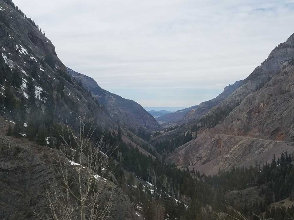
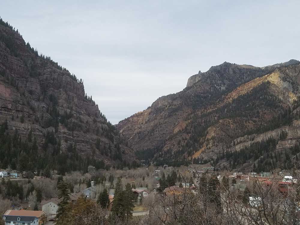
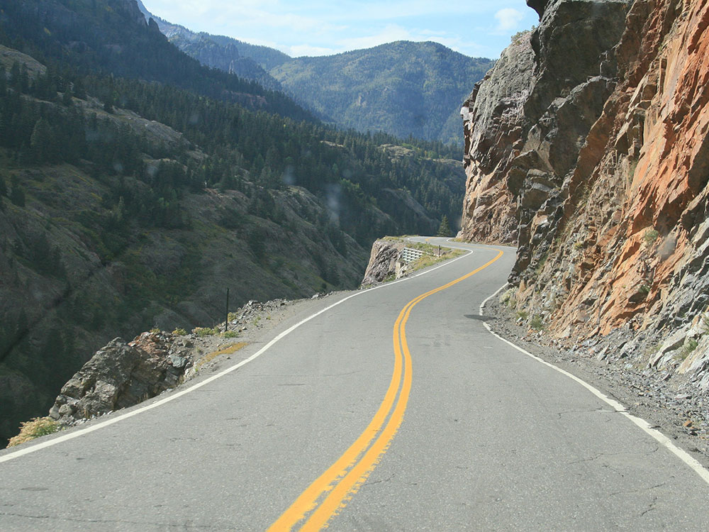
From Ridgway, the byway turns south onto US 550 following the Uncompahgre River into the Victorian mining town of Ouray. The highway is referred to as the Million Dollar Highway from Ouray south back to Durango. For the first 7.0 miles (11.3 km) south of Ouray the byway follows through the Uncompahgre Gorge. Just past the only tunnel on the route, just south of Ouray, the road crosses over Bear Creek Falls on a bridge at the location of an impassable toll booth on the original road. The Alpine Loop National Back Country Byway, a four wheel drive jeep road, takes off in the gorge south of Bear Creek Falls. Before leaving the gorge the byway passes through a snow shed under the Riverside Slide avalanche zone. A monument stands near here honoring those who have lost their lives in the avalanche, including several snowplow operators. At this point the byway enters Ironton Park, a nice flat valley in contrast to the gorge. The road ascends several switchbacks, or S-curves, past the Idarado mining operation to the 11,018-foot (3,358 m) summit of Red Mountain Pass, providing views of Red Mountain and several ghost towns. Back into the San Juan National Forest the highway descends through the Chattanooga Valley to Silverton.
From Silverton the byway passes over the 10,910-foot (3,330 m) Molas Pass and the 10,640-foot (3,240 m) Coal Bank Pass, descending past the ski resort of Purgatory Resort. From Hermosa, the road parallels the Durango and Silverton narrow gauge railroad before returning to Durango.
History
The San Juan Skyway was designated as a National Forest Scenic Byway in September 1988. It was later named a Colorado Scenic and Historic Byway in 1989 and an All-American Road in September 1996.
U.S. Route 550 (US 550) is a spur of U.S. Highway 50 that runs from Bernalillo, New Mexico to Montrose, Colorado in the western United States. The section from Silverton to Ouray is frequently called the Million Dollar Highway. It is one of the roads on the Trails of the Ancients Byway, one of the designated New Mexico Scenic Byways.
U.S. 550 begins just north of Albuquerque at Bernalillo and passes through the towns of San Ysidro, Cuba, Bloomfield, and Aztec. Except for sections passing through the above listed towns, U.S. 550 in New Mexico has been upgraded to four lanes, offering a high-speed (70 mph) connection for Farmington, New Mexico and Durango, Colorado to Albuquerque and Santa Fe.
Most of U.S. 550 in Colorado is two-lane mountainous highway. It is one of only two north-south U.S. Highways in Colorado which runs west of the Continental Divide. (The other route is US 491.) The route travels north through the San Juan Mountains.
The Million Dollar Highway stretches for about 25 miles (40 km) in western Colorado and follows the route of U.S. 550 between Silverton and Ouray, Colorado. It is part of the San Juan Skyway Scenic Byway. Between Durango and Silverton the Skyway loosely parallels the Durango and Silverton Narrow Gauge Railroad.
Though the entire stretch has been called the Million Dollar Highway, it is really the twelve miles (19 km) south of Ouray through the Uncompahgre Gorge to the summit of Red Mountain Pass which gains the highway its name. This stretch through the gorge is challenging and potentially hazardous to drive; it is characterized by steep cliffs, narrow lanes, and a lack of guardrails; the ascent of Red Mountain Pass is marked with a number of hairpin curves used to gain elevation, and again, narrow lanes for traffic—many cut directly into the sides of mountains. During this ascent, the remains of the Idarado Mine are visible. Travel north from Silverton to Ouray allows drivers to hug the inside of curves; travel south from Ouray to Silverton perches drivers on the vertiginous outside edge of the highway. The road is kept open year-round. Summer temperatures can range from highs between 70-90 °F (21-32 °C) at the ends of the highway to 50-70 °F (10-21 °C) in the mountain passes. The snow season starts in October, and snow will often close the road in winter. Chains may be required to drive.
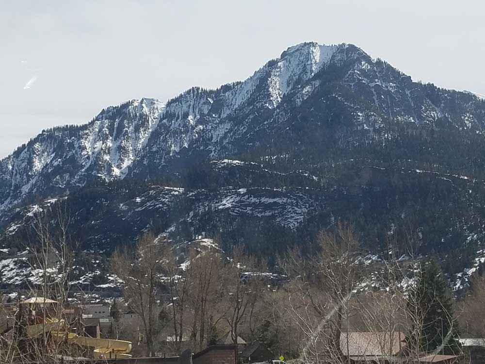
North of Durango, the highway passes by Trimble Springs, hot springs that have been open for visitors since the late 19th century. The highway runs north along the Animas River, under the Hermosa Cliffs. It enters the San Juan National Forest and goes past Haviland Lake and Electra Lake. Drivers pass by Engineer Mountain and Twilight Peak before crossing Coal Bank Pass. Next is Molas Pass, which offers a panoramic view of Molas Lake, the Animas River Gorge, and Snowdon Peak. Northbound travelers then pass through the town of Silverton, elevation 9,320 feet (2841 m), surrounded by 13,000 foot (4000 m) peaks Sultan Mountain, Kendall Mountain, and Storm Peak.
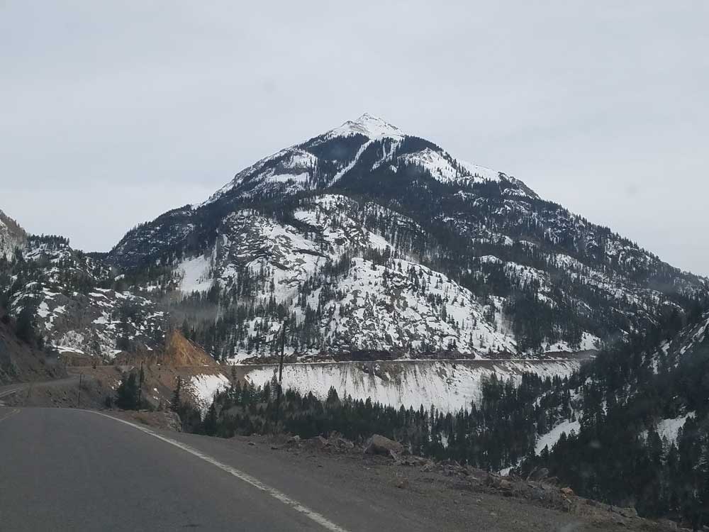
The highway leaves Silverton and proceeds up Mineral Creek Valley before ascending to Red Mountain Pass. The ruins of the Longfellow Mine are visible along the way. The highway then goes through a series of steep grades and hairpin turns before reaching Lookout Point, which offers a view of the town of Ouray.
This section of the route passes over three mountain passes:
- Coal Bank Pass, elevation 10,640 ft (3,240 m).
- Molas Pass, elevation 10,970 ft (3,340 m).
- Red Mountain Pass, elevation 11,018 ft (3,358 m).
The origin of the name Million Dollar Highway is disputed. There are several legends, though, including that it cost a million dollars a mile to build in the 1920s, and that its fill dirt contains a million dollars in gold ore.
U.S. 550 ends at the corner of Townsend Avenue and San Juan Avenue in Montrose, Colorado at the junction of its parent route U.S. Highway 50.
The original portion of the Million Dollar Highway was a toll road built by Otto Mears in 1883 to connect Ouray and Ironton. Another toll road was built over Red Mountain Pass from Ironton to Silverton. In the late 1880s Otto Mears turned to building railroads and built the Silverton Railroad north from Silverton over Red Mountain Pass to reach the lucrative mining districts around Red Mountain, terminating at Albany just eight miles (13 km) south of Ouray. The remaining eight miles (13 km) were considered too difficult and steep for a railroad. At one point a cog railroad was proposed, but it never made it beyond the planning stage.
In the early 1920s, the original toll road was rebuilt at considerable cost and became the present day US 550. The Million Dollar Highway was completed in 1924. Today the entire route is part of the San Juan Skyway Scenic Byway.
US 550 was part of the original 1926 federal highway system. The original highway extended 110 miles (177 km) from Montrose, Colorado at U.S. Highway 50 to U.S. Highway 450 (now U.S. Highway 160) at Durango, Colorado. In 1934, Highway 550 was extended through Farmington to Shiprock, New Mexico. In 1989, the western end of US 550 was replaced with US 64 between Farmington and Shiprock. In 2000, US 550 was extended further south from Aztec to Bernalillo to replace the newly upgraded NM 44 and NM 544, at which time all of US 550 in New Mexico was four lanes.
In 2009 US 50 was re-routed onto the San Juan Avenue bypass to avoid downtown Montrose. As a result, U.S. 550 was extended approximately one mile northwest to intersect with the new U.S. 50 alignment.
This article uses material from the Wikipedia article "San Juan Skyway", and "Million Dollar Highway", which is released under the Creative Commons Attribution-Share-Alike License 3.0
_between_Silverton_and_Ouray_in_Colorado_(29466637288).jpg)