.jpg)
Located between Sierra Nevada and White Mountains, area leads high up Big Pine Creek into the Sierra, to lakes, hiking trails, fishing, and rock climbing underneath the Palisades Range and the Palisade Glacier
Overview
Big Pine (formerly, Bigpine) is a community in Inyo County, California. Big Pine is located approximately 15 miles (24 km) south-southeast of Bishop, at an elevation of 3,989 feet (1,216 m).
Big Pine is located in the Owens Valley of California between the Sierra Nevada and the White Mountains, just west of the Owens River upstream of its diversion into the Los Angeles Aqueduct. It lies on U.S. Route 395, the main north-south artery through the Owens Valley, connecting the Inland Empire to Reno, Nevada. US 395 also connects Big Pine to Los Angeles via State Route 14 through Palmdale.
To the East, CA route 168 crosses the White Mountains over Westgard Pass to the basin and range province of Nevada, while Death Valley Road leads to Death Valley. To the East, CA route 168 crosses the White Mountains over Westgard Pass to the basin and range province of Nevada, while Death Valley Road leads to Death Valley.
To the West, Glacier Lodge Road leads high up Big Pine Creek into the Sierra, to lakes, hiking trails, fishing, and rock climbing underneath the Palisades Range and the Palisade Glacier.
Big Pine Creek
Big Pine Creek is a 12.1-mile-long (19.5 km) stream in Inyo County of eastern California, in the western United States. It flows from the eastern Sierra Nevada down to the Owens Valley, where it is a major tributary of the Owens River near Big Pine.
Course
The headwaters of Big Pine Creek are in the eastern slopes of the Sierra Nevada, near the border with Fresno County. The creek begins at the confluence of its North and South Forks, below the Palisades.
From there, the creek flows east-northeast, passing Crater Mountain of the Big Pine volcanic field and intersecting Big Pine Canal before joining the Owens River near the town of Big Pine. The total average runoff from the watershed is 52,000 acre-feet (64,000,000 m3), mostly from Big Pine Creek itself.
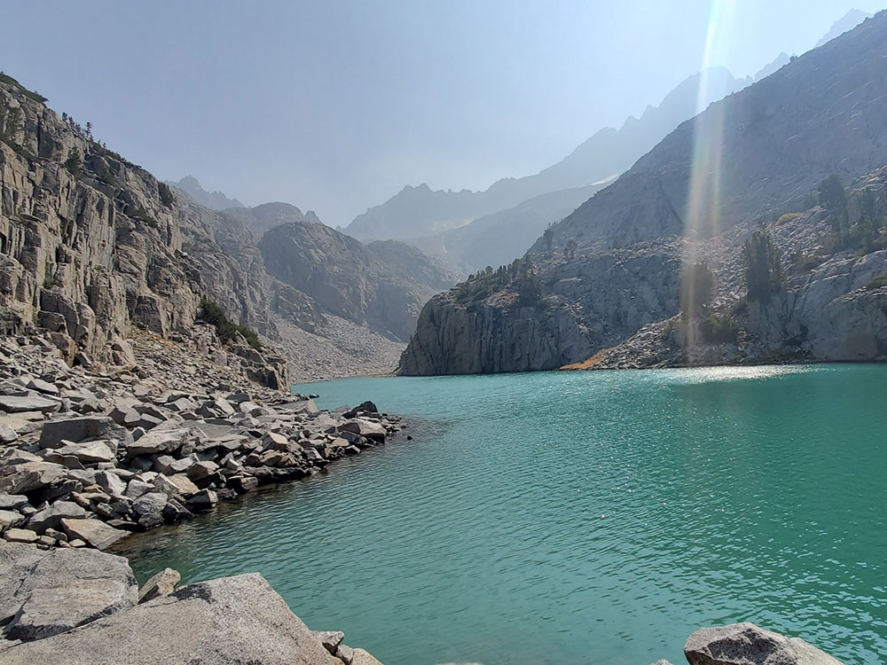
High above the cabin are numerous lakes, some which are of greenish hue due to glacial melt.
Big Pine volcanic field is a volcanic field in Inyo County, California. The volcanic field covers a surface area of 500 square kilometres (190 sq mi) within the Owens Valley east of the Sierra Nevada and consists of lava flows, one rhyolitic coulee and about 40 volcanic vents including cinder cones. Some vents are simple conical cinder cones while others are irregular scoria cones. Glaciers and former lakes have modified lava flows.
Volcanic activity in the field commenced 1.2 million years ago and was controlled by a number of faults which cross the valley. Activity continued into the Pleistocene with the youngest eruption generating cones and several lava flows about 17,000 years ago. A major road and the Los Angeles Aqueduct would be threatened if volcanic activity restarted at Big Pine.
The Big Pine volcanic field (also known as Aberdeen volcanic field) lies in the Owens Valley, around Aberdeen, California and between the towns of Big Pine and Independence. U.S. Route 395 and the Owens River run through the field, the latter is dammed north of the field in the Tinemaha Reservoir.
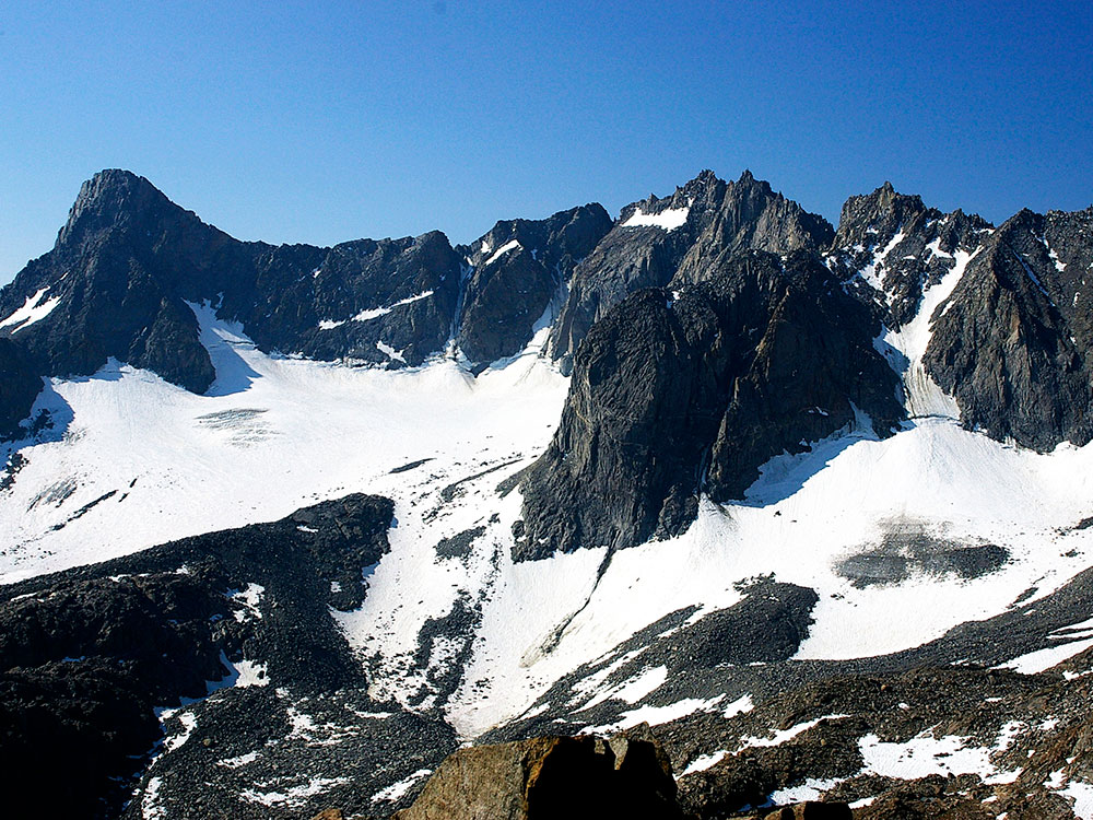
The Palisades (or the Palisade Group) are a group of peaks in the central part of the Sierra Nevada in California. They are located about 12 miles (19 km) southwest of the town of Big Pine, California. The peaks in the group are particularly steep, rugged peaks and "contain the finest alpine climbing in California." The group makes up about 6 miles (10 km) of the Sierra Crest, which divides the Central Valley watershed from the Owens Valley, and which runs generally northwest to southeast.
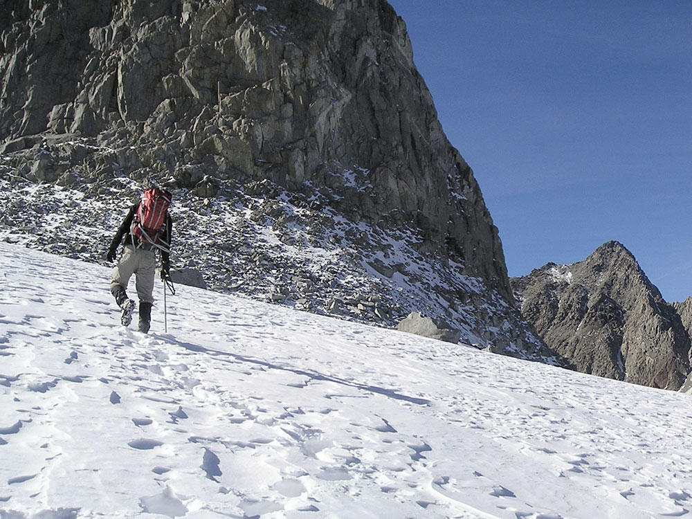
Although referred to by early geologists as "volcanic", the Palisades are a dark granitic rock. On the northeast side of the group lie the Palisade Glacier and the Middle Palisade Glacier, the largest glaciers in the Sierra Nevada. These glaciers feed Big Pine Creek.
Notable peaks of the group include four independent fourteeners:
- North Palisade, 14,248 ft (4,343 m)
- Mount Sill, 14,159 ft (4,316 m)
- Split Mountain, 14,064 ft (4,287 m)
- Middle Palisade, 14,018 ft (4,273 m) and the following mountains in addition:
- Mount Agassiz, 13,899 ft (4,236 m), the northwesternmost peak of the group before Bishop Pass.
- Birch Mountain, 13,608 ft (4,148 m), which juts out further towards the Owens Valley than the rest of the group.
- Norman Clyde Peak, 13,861 ft (4,225 m)
- Palisade Crest, 13,559 ft (4,133 m)
- Mount Gayley, 13,510 ft (4,118 m)
- Temple Crag, 12,982 ft (3,957 m), known for its many rock climbing routes.
- Temple Crag, 12,982 ft (3,957 m), known for its many rock climbing routes. The Thumb, 13,356 ft (4,071 m), also known as "East Palisade."
North Palisade has some additional subpeaks over 14,000 feet (4,267 m)
North Palisade is the third-highest mountain in the Sierra Nevada range of California, and one of the state's small number of peaks over 14,000 feet, known as fourteeners. It is the highest peak of the Palisades group of peaks in the central part of the Sierra range. It sports a small glacier (the Palisade Glacier) and several highly prized rock climbing routes on its northeast side.
The Palisade Glacier is a glacier located on the northeast side of the Palisades within the John Muir Wilderness in the central Sierra Nevada of California. The glacier descends from the flanks of four fourteeners, or mountain peaks over 14,000 ft (4,300 m) in elevation, including North Palisade (14,242 ft (4,341 m)), the highest peak of the Palisades group and the third highest peak in the Sierra Nevada overall.
Palisade Glacier is one of the few glaciers in California that terminates in a proglacial lake dammed by its former moraine, turquoise-colored from the glacial powder suspended in the water. The Big Pine Lakes below the glacier are also the same color.
This article uses material from the Wikipedia article "Big Pine, California", "Big Pine Creek (California)", "Big Pine volcanic field", "Palisades (California Sierra)", "North Palisade", and "Palisade Glacier", which is released under the Creative Commons Attribution-Share-Alike License 3.0.
 James Jernigan SEO, CC BY-SA 4.0, via Wikimedia Commons ; Image Size Adjusted
-1000.jpg) Jim Morefield from Nevada, USA, CC BY-SA 2.0, via Wikimedia Commons ; Image Size Adjusted
Jim Morefield from Nevada, USA, CC BY-SA 2.0, via Wikimedia Commons ; Image Size Adjusted.jpg)