Expansive wilderness of colorful cliffs, deep canyons, and remote plateaus offering rugged backcountry hiking, scenic vistas, and rare wildlife viewing.
General Information
No visitor centers within the monument
Arizona Strip Visitor Center in St. George, UT: Mon–Fri, 8:00 AM – 4:30 PM
Permits required for Coyote Buttes North (The Wave), Coyote Buttes South, and overnight trips in Paria Canyon
Camping: Free (dispersed only, outside wilderness areas)
Permitted in Coyote Buttes and Paria Canyon with permit
Must be leashed (max 6 ft), not left unattended, and cleaned up after
How to Get There
From Page, AZ (40 mi): Take US-89 S to House Rock Valley Road, then drive south on the unpaved road to access trailheads and scenic areas; high-clearance vehicles recommended.
Overview
Vermilion Cliffs National Monument is located in northern Coconino County, Arizona, immediately south of the Utah state line. This national monument, 293,689 acres (118,852 ha) in area, protects the Paria Plateau, Vermilion Cliffs, Coyote Buttes, and Paria Canyon. Elevations in the monument range from 3,100 feet to 6,500 feet above sea level (944 to 1,981 meters).
Creation and designation
Established on November 9, 2000 by a presidential proclamation by President Bill Clinton, Vermilion Cliffs National Monument was carved from existing lands already under the management of the U.S. Government in extreme northern Coconino County, Arizona, immediately south of the border with the state of Utah. The monument is administered by the U.S. Bureau of Land Management, an agency within the U.S. Department of the Interior. The Vermilion Cliffs themselves run along the southern and eastern edges of the monument. Much of the monument's land consists of the Paria Plateau, a flat area extending northward from the tops of the cliffs.
Vermilion Cliffs
The Vermilion Cliffs are steep eroded escarpments consisting primarily of sandstone, siltstone, limestone, and shale which rise as much as 3,000 feet (910 m) above their bases. These sedimentary rocks have been deeply eroded for millions of years, exposing hundreds of layers of richly colored rock strata. Mesas, buttes, and large tablelands are interspersed with steep canyons, where some small streams provide enough moisture to support a sampling of wildlife.
Flora and fauna
More than twenty species of raptors, including bald eagles and golden eagles, peregrine falcons, and several hawk species, have been observed. The endangered California condor has been re-introduced into this region recently due to its remote location and lack of human habitation. Desert bighorn sheep, pronghorns, and mountain lions make up most of the large mammals found here, with about 30 more species of smaller mammals. Several examples of rare fish species, such as the flannelmouth sucker and the speckled dace live in the streams of the monument. The Welsh's milkweed, a threatened plant species that grows on sand dunes and helps stabilize them, is known to exist only in the monument and one other area in neighboring Utah.
Human settlements
Human settlement in the region dates back 12,000 years, and hundreds of Native American pueblos are spread across the monument. The remains of the natives' villages, with houses, granaries, burial areas, and associated ruins, can be found here. The monument also contains one of the largest number of rock art sites in any nationally protected area. Many of these petroglyphs are believed to be among the oldest in the United States.
The first explorers into the region were Spanish missionaries and explorers from the 1776 Domínguez–Escalante expedition. Later, Mormon explorers searched the region during the 1860s, some of them settling on land that is now within the monument. They built one of the first ferry crossings on the Colorado River in 1871. That same year, John Wesley Powell ventured through this region during his scientific explorations of the Colorado River plateau.
Below the Vermilion cliffs runs the historic "Honeymoon Trail", a wagon route for Mormons who journeyed to have their marriages sealed in the temple at St. George, Utah, and then to return. The route, through remote country, was otherwise seldom used. Historical markers denote this history.
Today, the region surrounding the monument is relatively unspoiled with virtually no permanent inhabitants remaining and limited road access.
Coyote Buttes is a section of the Paria Canyon-Vermilion Cliffs Wilderness managed by the Bureau of Land Management (BLM), spanning extreme south-central Utah and north-central Arizona, south of US 89 halfway between Kanab, Utah and Page, Arizona. It is divided into two areas: Coyote Buttes North and Coyote Buttes South. Visiting either of the Coyote Buttes areas requires purchasing a hiking permit.
The Coyote Buttes area is an exposure of cross-bedded aeolian Jurassic Navajo Sandstone. The variable coloration of the sandstones is a result of various iron oxide pigments within the layers. A dinosaur trackway or trample surface is found in the area and provides evidence of a variety of dinosaurs. The area includes dramatic swirling erosional rock formations such as The Wave. The Wave and Buckskin Gulch share the Wire Pass Trailhead on House Rock Valley Road.
The dinosaur trackway within the area is a site of 0.75 acres that has densely packed dinosaur footprints within the area. The trackway contains more than 1,000 footprints which were made approximately 190 million years ago. Tracks of three genera of Eubrontes, Anchisauripus and Grallator are present along with a Sauropodomorph that has not been identified.
This article uses material from the Wikipedia article "Vermilion Cliffs National Monument", and "Coyote Buttes", which is released under the Creative Commons Attribution-Share-Alike License 3.0
Featured Trail
-400.jpg)
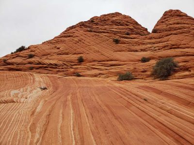
Coyotte Buttes South
Remote sandstone landscape of eroded rock formations, ridges, and sculpted domes displaying vivid layers of red, orange, and white created by millions of years of geological processes.
Paria River
Tributary of the Colorado River, approximately 95 miles (153 km) long, flowing through roadless slot canyons along part of its course and is one of the most popular destinations for canyoneering in the region.
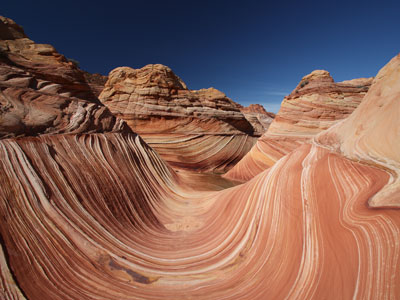
The Wave
Sandstone rock formation located in Arizona, near border with Utah is well-known among hikers and photographers for its colorful, undulating forms

White Pocket
Remote sandstone formations of swirling white and red rock create an otherworldly landscape of domes, ridges, and intricate patterns shaped by wind and erosion.


