Preserved cliff dwellings built by Ancestral Puebloans, surrounded by high desert mesas and accessible via scenic trails and seasonal guided hikes.
General Information
Visitor Center: Summer (May–Sept): 9:00 AM – 5:00 PM MDT
Closed: Thanksgiving, Christmas, and New Year’s Day
Trails and campground remain open even when Visitor Center is closed
Ranger-led tours to Betatakin and Keet Seel: Free (advance reservation required)
Not permitted on trails or in buildings
Must be leashed (max 6 ft) and cleaned up after
How to Get There
From Page, AZ (125 mi): Take US-89 S to US-160 E, then turn north on AZ-564 and follow signs to the monument entrance.
Overview
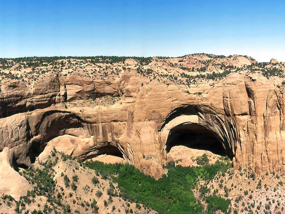
Navajo National Monument is a National Monument located within the northwest portion of the Navajo Nation territory in northern Arizona, which was established to preserve three well-preserved cliff dwellings of the Ancestral Puebloan people: Keet Seel (Broken Pottery) (Kits'iil), Betatakin (Ledge House) (Bitát'ahkin), and Inscription House (Ts'ah Bii' Kin). The monument is high on the Shonto plateau, overlooking the Tsegi Canyon system, west of Kayenta, Arizona. It features a visitor center with a museum, three short self-guided trails, two small campgrounds, and a picnic area.
The Sandal Trail is an accessible self-guided 1.3 mi (2.1 km) roundtrip trail that ends at an overlook of the Betatakin ruins across the 560-foot-deep (170 m) Betatakin Canyon. The overlook is the only point in the monument where visitors can view the cliff dwelling other than on the guided tours. Rangers guide visitors on free (3-5 hour long) tours of the Betatakin cliff dwellings and on 17 mi (27 km) roundtrip back-country hikes to the Keet Seel. The Inscription House site, further west, has been closed to public access for many years.
Keet Seel
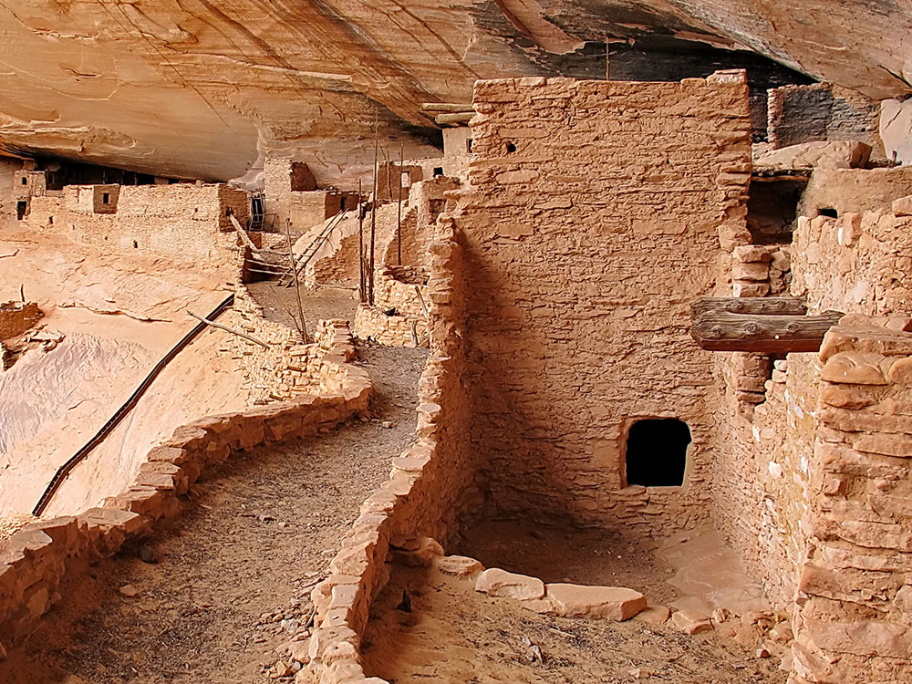
Keet Seel or Kiet Siel (Kįts'iil), which stands for "broken pottery scattered around" in Navajo, is a well preserved cliff dwelling of the ancient Anasazi (ancestral puebloans) people located in a branch of the Tsegi Canyon in the Kayenta region. The site was first occupied at around 1250, during a time in which a large number of people were believed to be aggregating in sites such as this in this part of the American Southwest. There was a construction boom at Keet Seel between 1272 and 1275, with construction then slowly tapering off and halting completely at 1286. Once construction halted in 1286, there was no evidence of structures being built until its subsequent abandonment some 20 years later. It is believed that, at its peak, up to 150 people inhabited this site at one time. Due to the extremely dry climate and natural overhanging cliff the site's dwellings and artifacts are well preserved. Keet Seel is considered by many archaeological experts to be one of the best preserved larger ruins in the American Southwest.
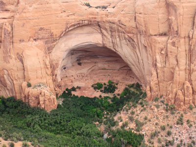
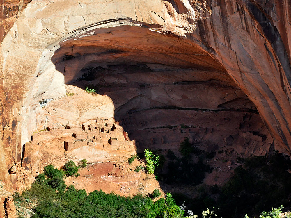
Betatakin means "House Built on a Ledge" in Navajo. In Hopi, the name of the place is Talastima, or "Place of the Corn Tassel". Betatakin is smaller than nearby Keet Seel, with about 120 rooms at the time of abandonment. However, like Keet Seel, Betatakin was constructed of sandstone, mud mortar, and wood. Today only about 80 rooms remain, due to rock falls inside the alcove. Betatakin only has one kiva, whereas Kiet Siel has several. Betatakin was built in an enormous alcove, measuring 452 feet high and 370 feet across, between 1267 and 1286.
The first excavations occurred in 1909 under Byron Cummings, University of Utah, and continued into the 1950s and 1960s under archaeologists like Jeffery Dean. During its two-decade heyday Dean estimated a maximum population of about 125 people.
Three (3) self-guided trails are available to use from sunrise to sunset even when the park is closed. Trails can be accessed from the parking lot and begin behind the visitor center building.
- Sandal Trail: a 1.3 mile (2.09 km) round-trip paved trail to the Betatakin Cliff Dwelling overlook. The Betatakin Cliff Dwellings can be seen from a 1/4 mile distance so bringing binoculars is recommended. The trail is paved with a 150 feet elevation change. The trail generally takes 30 minutes to walk the entire length depending on the amount of time spent at the overlook. NOTICE: This is the only point in the park where visitors can view the cliff dwelling other than on the guided tours.
- Aspen Trail: 0.8 mile (1.29 km) steep round-trip nature trail that leads to an overlook of a relict forest on the canyon floor. The elevation change is 350 feet and is strenous for non-hikers. The trail generally takes 30-45 minutes depending on the amount of time spent at the overlook. NOTICE: Cliff dwellings can not be seen from here.
- Canyon View Trail: 0.8 mile (1.29 km) round-trip canyon rim trail that leads to the park's historic ranger station and provides views of the canyon. The trail is flat and is not paved. The trail generally takes 15-20 minutes to walk the entire length. Notice: Cliff dwellings can not be seen from here.
The park offers ranger guided cliff dwelling tours during the summer season which run from Memorial Day to Labor Day (late May to early September).
- Betatakin (CLOSED): During the summer season, two (2) tours are offered at 8:15am MDT and 10:00am MDT. The trails are 3 miles (4.83 km) or 5 miles (8.05 km) roundtrip depending on which tour you join. Tours are 3-5 hours in length. A sign up sheet is available at the visitor center. We do not accept reservations for the Betatakin hike.
- Keet Seel (CLOSED): A 17 mile (27.4 km) roundtrip backcountry hike is required to access Keet Seel. A reservation made by phone or in person is required to obtain a permit. The park will begin accepting phone and in person reservations February 1, 2021 for the 2021 summer season.
This article uses material from the Wikipedia article "Navajo National Monument", which is released under the Creative Commons Attribution-Share-Alike License 3.0
-1000.jpg)
.jpg)