Expansive desert landscape featuring mesas, canyons, and archaeological sites with opportunities for hiking, wildlife viewing, and primitive camping.
General Information
Visitor Center (Black Canyon Heritage Park): 9:00 AM – 1:00 PM daily
Closed: New Year’s Day, Easter, Memorial Day, July 4, Labor Day, Veterans Day, Thanksgiving, Friday after Thanksgiving, Christmas Eve, Christmas Day
Camping: Free (dispersed/primitive only)
Must be leashed (max 6 ft), not left unattended, and cleaned up after
How to Get There
From Phoenix, AZ (40 mi): Take I-17 N toward Flagstaff and exit at Badger Springs Road or Bloody Basin Road for access to trailheads and scenic areas within the monument.
Overview
Agua Fria National Monument, a unit of the BLM's National Landscape Conservation System, includes 450 distinct Native American structures that have been recorded in the monument, some of large pueblos containing more than 100 rooms each. The enhanced protection status also provides greater habitat protection for the numerous plant and animal communities. It is located approximately 40 miles (64 km) north of downtown Phoenix, Arizona.
Antiquities
Ruins of a village built by Puebloans about 1000 years ago on top of Indian Mesa. This is part of the wall of the fort that surrounded the village. The holes in the wall are viewing holes so the defenders can view the only path to the top. There are several branches of an ocotillo plant in the foreground. Petroglyphs are scattered across the numerous puebloan ruins, which were built between 1250 and 1450 C.E. when several thousand Native Americans, known as the Perry Mesa Tradition, inhabited the region. The petroglyphs depict animals, geometric figures and abstract symbols and are found by the thousands. Numerous ruins of agricultural terraces and irrigation devices indicate that farming was widespread during this period. Other historical entities that are found include 19th century mining features and Basque sheep camps.
Natural history
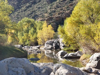
Situated between 2,150 feet (660 m) and 4,600 feet (1,400 m) in elevation, the monument is primarily composed of semi-desert grassland but also contains extensive riparian stands of cottonwoods and willows which are tied to the Agua Fria River. More than 140 bird species have been recorded at the monument. Notable species of reptiles and amphibians, including the leopard frog, the garter snake, and the desert tortoise, can be seen at the monument. Mammals such as the pronghorn, mule deer, white-tail deer and javelina are relatively common. The elk, black bears and mountain lions are also found in the monument, but are much less common. Native fish including the longfin dace, the Gila mountain sucker, speckled dace, and three endangered native fish including the Gila intermedia, charalito, and desert pupfish exist in the 129-mile (208 km)-long Agua Fria River and its tributaries.
This article uses material from the Wikipedia article "Agua Fria National Monument", which is released under the Creative Commons Attribution-Share-Alike License 3.0.
Featured Trails

Badger Springs Canyon Trail
1.6 mile roundtrip, 100ft elevation
The only major hiking path in the monument, the 0.8 mile route along Badger Springs Canyon, a west-side tributary of the Agua Fria River.

