Monument marks the quadripoint in the Southwestern United States where the states of Arizona, Colorado, New Mexico, and Utah meet
General Information
Spring/Summer (Apr–Sept): 8:00am to ~5:45pm (varies by season)
Closed on major holidays including Thanksgiving, Christmas, and New Year’s Day
Children 6 and under: Free
Cash or card depending on availability
How to Get There
From Farmington, NM (60 mi): Take US‑64 W to US‑160 W toward Teec Nos Pos, then follow signs for the monument and continue south on access roads leading directly to the site entrance.
Overview
The Four Corners Monument marks the quadripoint in the Southwestern United States where the states of Arizona, Colorado, New Mexico, and Utah meet. It is the only point in the United States shared by four states, leading to the area being named the Four Corners region. The monument also marks the boundary between two semi-autonomous Native American governments, the Navajo Nation, which maintains the monument as a tourist attraction, and the Ute Mountain Ute Tribe Reservation.
The origins of the state boundaries marked by the monument occurred just prior to, and during, the American Civil War, when the United States Congress acted to form governments in the area to combat the spread of slavery to the region. When the early territories were formed, their boundaries were designated along meridian and parallel lines. Beginning in the 1860s, these lines were surveyed and marked. This includes the Four Corners Monument, which has been legally established as the corner of the four states.
Monument
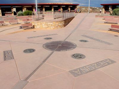
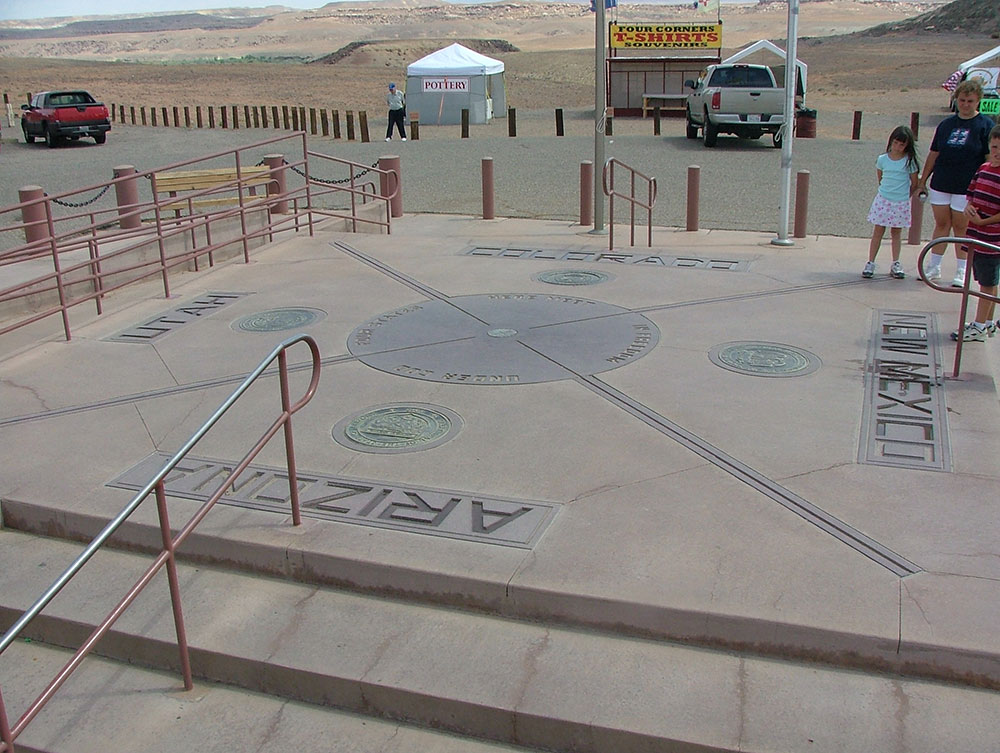
The monument is maintained as a tourist attraction by the Navajo Nation Parks and Recreation Department. It is an example of a political boundary that is a tourist destination in its own right. The monument consists of a granite disk embedded with a smaller bronze disk around the point, surrounded by smaller, appropriately located state seals and flags representing both the states and tribal nations of the area. Circling the point, starting from Colorado, the disk reads with two words in each state "Here meet in freedom under God four states". Around the monument, local Navajo and Ute artisans sell souvenirs and food. An admission fee is required to view and photograph the monument. The monument is a popular tourist attraction despite its remote and isolated location. As early as 1908, people traveled long distances to take pictures of family and friends at the monument in Twister-like poses, sitting on the disk, in a circle of friends or family around the disk, or for couples to kiss directly over the disk.
The monument is located on the Colorado Plateau west of U.S. Highway 160, approximately 40 miles southwest of Cortez, Colorado. In addition to the four states, two semi-autonomous American Indian tribal governments have boundaries at the monument, the Navajo Nation and the Ute Mountain Ute Tribe Reservation, with the Ute Mountain tribal boundaries coinciding with Colorado's boundaries at the monument.
After the Civil War, efforts began to survey and mark the actual borders. In 1868, the General Land Office (GLO) had Ehud N. Darling survey and set markers along the border between the Colorado and New Mexico Territories (the 37th parallel north); this border over time has become known as the "Darling Line". In 1875, another GLO surveyor, Chandler Robbins, surveyed and marked the border between the Arizona and New Mexico Territories (the 32nd meridian west of Washington). Robbins began near the Mexico-United States border, and worked his way north marking the border every so often. Near the 37th parallel north he intersected the Darling Line, and here he erected a sandstone shaft. This sandstone shaft marked today's location of the Four Corners Monument.
In 1878, Rollin J. Reeves surveyed and marked the border between the newly created State of Colorado and the Utah Territory. Reeves located the sandstone shaft marker placed by Robbins at today's Four Corners Monument. He then began to survey and mark the border between Colorado and Utah from this point northward. In 1901, Howard B. Carpenter surveyed and marked the border between Arizona and Utah, completing the survey of borders making up the Four Corners Monument.
The results of these surveys and the markers placed were later accepted as the legal boundaries between the various states.
By 1899, the sandstone shaft marker placed by Chandler Robbins in 1875 had been disturbed and broken, so it was replaced with a new stone by two U.S. surveyors, Hubert D. Page and James M. Lentz. In 1912, a simple concrete pad was poured around the marker. The first modern Navajo government convened in 1923 in an effort to organize and regulate an increasing amount of oil exploration activities on Navajo lands, and they would play a big role in the monument's further development. In 1931, Everett H. Kimmell, another U.S. surveyor, found this newer stone had broken too and he replaced it with a brass disc marker set in concrete. In 1962, the Bureau of Land Management and the Bureau of Indian Affairs poured an elevated concrete pad around the 1931 brass marker; this pad included the state border lines and names in tile. The monument was completely rebuilt in 1992, and the 1931 brass marker was replaced with a disc shaped aluminum-bronze plate set in granite. The monument was again rebuilt in 2010, although the disc shaped plate from 1992 remained in place.
This article uses material from the Wikipedia article "Four Corners Monument", which is released under the Creative Commons Attribution-Share-Alike License 3.0
-1000.jpg)
.jpg)