State park containing badlands with mesquite, cacti and junipers with tall grasses, plums, hackberries and cottonwoods in the canyons
General Information
Last updated 9/11/2022
Park often reaches capacity; reservations are highly recommended for both camping and day use. To guarantee entrance reserve passes online, or by calling the customer service center
Child 12 Years and Under: Free
From Amarillo (102 miles): Follow I-27 S and TX-86 E to Ranch Rd 1065/Geisler in Quitaque. Continue on Ranch Rd 1065 to destination.
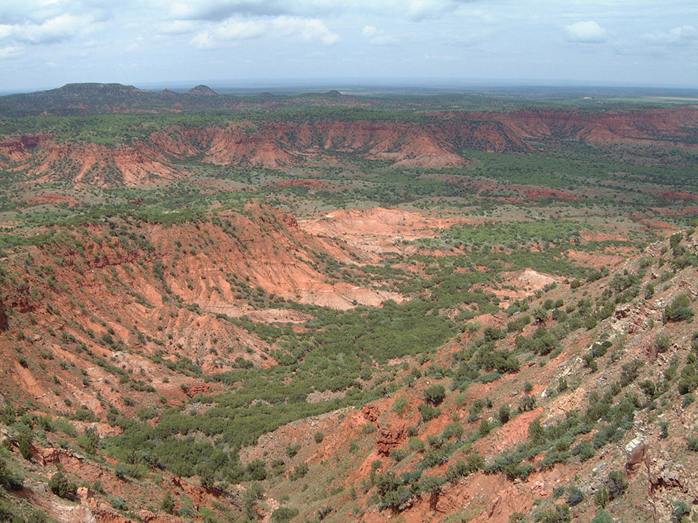
Caprock Canyons State Park and Trailway is a Texas state park located along the eastern edge of the Llano Estacado in Briscoe County, Texas, approximately 100 miles (160 km) southeast of Amarillo. The state park opened in 1982 and is 15,314 acres (6,197 ha) in size, making it the third-largest state park in Texas.
In 1993, a hiking, biking, and equestrian rail trail opened that stretches through the park through Floyd, Briscoe, and Hall counties. The trailway was created after the Texas Parks and Wildlife Department acquired 64.25 miles (103 km) of right-of-way from the abandoned Fort Worth and Denver Railroad's lines between Estelline and South Plains.
The area contains badlands with mesquite, cacti and junipers with tall grasses, plums, hackberries and cottonwoods in the canyons.
The Park hosts part of the Texas state bison herd. At the urging of his wife, Charles Goodnight preserved several plains bison from those that were being slaughtered. This herd became one of the genetic sources from which current bison herds descend. The state herd only contains plains bison which have no cattle DNA.
African sheep (Barbary sheep), mule deer, white-tailed deer, coyotes, opossums, raccoons, bobcats, foxes, porcupines, numerous species of snakes and lizards, and over 175 species of birds including golden eagles are found within the park. Lake Theo contains bass, catfish, and rainbow trout. In the summer of 2012 black-tailed prairie dogs were reintroduced to a 200-acre (81 ha) area within the park.
Things to Do
See the Official Texas State Bison Herd
Caprock Canyons is home to the Official Texas State Bison Herd, descendants of animals preserved by rancher Charles Goodnight. Visitors can often observe bison grazing across the prairie, near roads, and throughout much of the park.
Hike Through Red Rock Canyons
Explore more than 25 miles of park trails that wind through rugged canyons, colorful cliffs, prairie landscapes, creek beds, and scenic overlooks. Trails range from easy canyon-rim walks to challenging backcountry routes.
Visit Haynes Ridge Overlook
One of the park's most famous hikes leads to Haynes Ridge, where hikers are rewarded with panoramic views of the Caprock Escarpment and surrounding canyon country.
Hike Eagle Point Trail
This popular moderate trail descends from the plains into the canyon and passes a natural bridge carved by erosion. The route offers excellent scenery and opportunities to spot wildlife.
Explore the Canyon Rim Trail
Enjoy sweeping views of Holmes Creek Canyon while walking through mixed-grass prairie habitats where native wildlife is frequently seen.
Ride the Caprock Trailway
The park connects to a 64-mile rail-trail corridor popular with hikers, cyclists, and horseback riders. The trailway passes through dramatic canyon scenery and historic railroad features.
Visit Clarity Tunnel
This former railroad tunnel is home to a large colony of Mexican free-tailed bats. During warmer months, visitors can watch thousands of bats emerge in the evening.
Top Trails
Haynes Ridge Overlook Trail
Distance: 2.3 miles one way
Difficulty: Very Challenging
Highlights: The park's premier overlook with approximately 600 feet of elevation gain and spectacular panoramic canyon views.
Eagle Point Trail
Distance: 2 miles one way
Difficulty: Moderate
Highlights: Scenic transition from prairie to canyon landscapes with a natural bridge and frequent wildlife sightings.
Canyon Rim Trail
Distance: 3 miles
Difficulty: Moderate
Highlights: Outstanding canyon overlooks and opportunities to observe wildlife across the grasslands and escarpment.
Upper North Prong Trail
Distance: Varies depending on route
Difficulty: Moderate to Challenging
Highlights: Colorful canyon walls, remote scenery, creek crossings, and access to some of the park's most dramatic landscapes.
Mesa Trail
Distance: 3.1 miles round trip
Difficulty: Moderate
Highlights: Circles a flat-topped mesa and provides expansive views of the southeastern portion of the park.
Highlights
The Caprock Escarpment
The park protects a dramatic section of the Caprock Escarpment, a geological boundary where the High Plains descend into rugged canyon country.
Texas State Bison Herd
One of the most significant conservation herds in North America roams freely throughout much of the park.
Colorful Canyon Landscapes
Layers of red, orange, and white rock reveal millions of years of geological history while creating some of Texas' most dramatic scenery.
Clarity Tunnel Bat Colony
The historic railroad tunnel provides seasonal habitat for thousands of Mexican free-tailed bats.
This article uses material from the Wikipedia article "Caprock Canyons State Park and Trailway", which is released under the Creative Commons Attribution-Share-Alike License 3.0