Park situated around a steep gorge in which the Falling Water River drops 250 feet (76 m) in elevation in less than a mile, culminating in a 136-foot (41 m) cataract waterfall
General Information
August 16–October 31: 8:00am to 6:00pm
November 1–Second Sunday in March: 8:00am to 4:00pm
Second Saturday in March–April 30: 8:00am to 6:00pm
No admission fee required
Summer: Full access to trails and lush scenery
Fall: Excellent foliage and comfortable hiking temperatures
Winter: Fewer crowds and enhanced waterfall views through leaf-off forests
How to Get There
From Cookeville (15 mi): Take TN-135 N from Cookeville, continue approximately 15 miles toward Sparta, then follow signs to Burgess Falls State Park and turn onto Burgess Falls Drive to reach the park entrance.
Overview
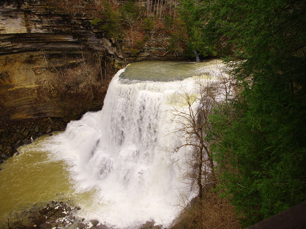
Burgess Falls State Park is a state park and state natural area in Putnam County and White County, Tennessee. The park is situated around a steep gorge in which the Falling Water River drops 250 feet (76 m) in elevation in less than a mile, culminating in a 136-foot (41 m) cataract waterfall.
Geography
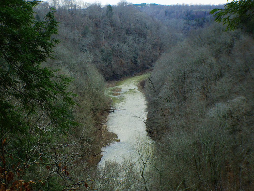
The Falling Water River rises near the base of the Cumberland Plateau in eastern Putnam County and winds its way across the Highland Rim to its mouth along the Center Hill Lake impoundment of the Caney Fork, which is located in an area where the Highland Rim drops off into the Central Basin. The Burgess Falls State Natural Area comprises the section of the river just above its mouth, where the river drops from roughly 900 feet (270 m) atop the Highland Rim to just over 600 feet (180 m) at Center Hill Lake.
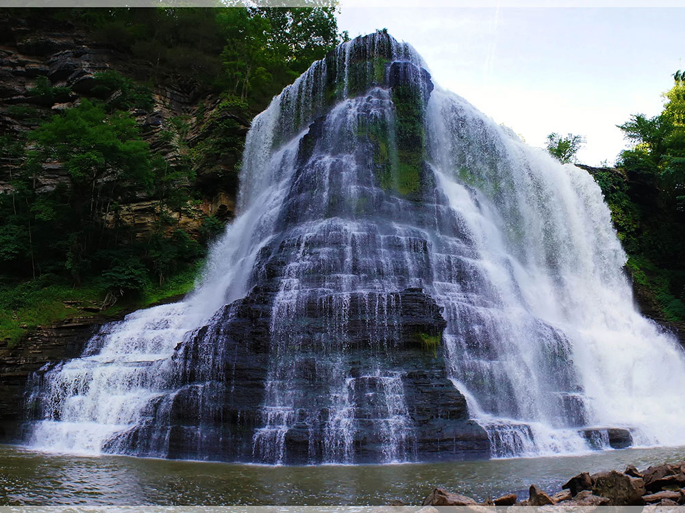
Over a long period of time, the Falling Water River's rapids have cut a deep gorge just above its mouth. The river drops to the Central Basin in a series of cascades and waterfalls, each gaining in size and intensity as the river approaches Center Hill Lake. At the Falling Water Cascades, located just downstream from the old Burgess Falls Dam, the river gradually spills over a 10-foot (3.0 m) embankment of rocks. Almost immediately downstream from the Cascades, the river drops another 30 feet (9.1 m) at Little Falls. Beyond Little Falls, where the river briefly bends to the north, is an 80-foot (24 m) cascade known as Middle Falls. Downstream from Middle Falls, where the river bends westward again, is the 136-foot (41 m) Burgess Falls. The distance between Falling Water Cascades and Burgess Falls is less than a mile. Burgess Falls spills into a large limestone gorge enclosed by sheer walls 100-200 feet (30-60 m) high. The Falling Water River enters Center Hill Lake downstream from Burgess Falls.
The entrance to Burgess Falls State Park is located just off Tennessee State Route 135 roughly halfway between Cookeville and Sparta.
A 1.5-mile (2.4 km) loop trail follows the bluffs along the south bank of the gorge, starting at Falling Water Cascades and ending at a platform overlooking Burgess Falls. Little Falls and Middle Falls are also visible from the trail. A stairway leads down to the overhang of Burgess Falls and continues down into the gorge. A second loop trail follows the ridgeline southwest of Burgess Falls.
The Burgess Falls State Natural Area includes Burgess Falls Lake and part of the forest on the both sides of the river in the lake's vicinity.
Things to Do
Hike to Burgess Falls
The park's most popular activity is hiking the River Trail, which follows the Falling Water River and passes multiple waterfalls before reaching the overlook of Burgess Falls. The trail allows visitors to experience the power and beauty of the river's cascading water as it moves through a rugged gorge.
View Four Waterfalls
One of the park's unique features is the opportunity to see four distinct waterfalls along a relatively short route. First Falls, Middle Falls, Upper Falls, and the towering Burgess Falls each provide a different perspective of the river's descent through the canyon.
Enjoy Scenic Overlooks
Several overlooks throughout the park provide panoramic views of the waterfalls, cliffs, and river gorge. The overlook at Burgess Falls offers the park's signature viewpoint and is one of the most photographed natural scenes in Tennessee.
Paddle to the Base of Burgess Falls
Although visitors cannot reach the base of Burgess Falls from within the park, paddlers can access it by kayak or canoe from nearby Cane Hollow Recreation Area. Approaching the waterfall from the water provides a unique perspective of the 130-foot cascade.
Explore the Ridge Top Trail
For visitors looking for a quieter experience, the Ridge Top Trail offers a pleasant walk through wooded terrain with views of the river corridor and surrounding forest.
Visit the Butterfly Garden
The butterfly garden near the park facilities serves as habitat for butterflies and pollinators, providing an additional natural attraction for visitors interested in the area's ecosystems.
Top Trails
River Trail
Length: 1.5 miles round trip
Elevation Gain: Approximately 250 feet
Difficulty: Moderate
The park's signature trail follows the Falling Water River past First Falls, Middle Falls, and Upper Falls before reaching the overlook for the dramatic 130-foot Burgess Falls. This is the must-do hike for first-time visitors.
Ridge Top Trail
Length: Approximately 1.5 miles one way
Elevation Gain: Minimal
Difficulty: Easy
This quieter trail travels through wooded ridgeline terrain and provides an alternative to the more heavily traveled River Trail. It is ideal for visitors seeking a less crowded experience.
Service Road Route
Length: Approximately 1.5 miles round trip
Elevation Gain: Moderate
Difficulty: Easy
Many visitors use the service road as an alternative return route from Burgess Falls. The wider path offers a gentler walking experience while still providing access to the main waterfall overlook.
This article uses material from the Wikipedia article "Burgess Falls State Park", which is released under the Creative Commons Attribution-Share-Alike License 3.0 Sources: Tennessee State Parks official Burgess Falls State Park information and visitor guidance. [1](https://us-prod.asyncgw.teams.microsoft.com/v1/objects/0-wus-d12-fc27e758ef750908c81de45d3fa37c42/views/original) Additional trail information and visitor details verified through park guides, hiking resources, and visitor reports. [2](https://www.nps.gov/biso/planyourvisit/hiking.htm)[3](https://backyardknoxville.com/things-to-do-in-big-south-fork/)[4](https://backyardknoxville.com/12-favorite-big-south-fork-hiking-trails/)[5](https://thetouristchecklist.com/big-south-fork/)[6](https://thenatureseeker.com/10-best-things-to-do-in-big-south-fork-tennessee/)
-1000.jpg)
.jpg)