Best known as the site of the historic 1980 volcanic eruption and offers a variety of recreation opportunities, including the chance to climb to the summit
General Information
Mount St. Helens Visitor Center
ALERT: The Mount St. Helens Visitor Center is closed at this time for construction and renovation.
- March 1 to May 15: open daily 9am to 4pm
- May 16 to Sept. 15: open daily 9am to 5pm
- Sept. 16 to Oct. 31: open daily 9am to 4pm
- Nov. 1 to Feb. 28: open Thursday through Monday 9am to 4pm
- The center is closed in observance of the following holidays: New Year's Day, Martin Luther King Jr. Day, Presidents' Day, Veterans Day, Thanksgiving, and the Friday after Christmas
Johnston Ridge Observatory
ALERT: Area Status Closed
Mount St. Helens Visitor Center at Silver Lake:
- Ages 6 and younger: Free
- Ages 7 to 17: $2.50
- Ages 18 and older: $5
- Family: $15 (two adults plus accompanying children)
Johnston Ridge Observatory: No fees
Crater climbing permits are $22/person May 15 though October 31st, a climbing quota is in effect with a limit of 100 climbers per day.
How to Get There
To Mount St Helens Visitor Center (116 miles): Follow I-5 S to Huntington Ave N in Cowlitz County. Take exit 49 from I-5 S. Follow WA-504 E to vsitor center.
To Johnston Ridge Observatory (155 miles): Follow I-5 S to WA-505 E in Lewis County. Take exit 63 from I-5 S. Drive to WA-504 E in Cougar.
To Windy Ridge Viewpoint (143 miles) Follow I-5 S, WA-7 S and US-12 E to WA-131 S in Randle. Take NFD 25, NF-26 and NF-99 to your destination in Cougar
To Climbers Biouvac Trailhead (186 miles): Follow I-5 S to Dike Access Rd in Cowlitz County. Take exit 22 from I-5 S. Take Lewis River Rd to 830 Rd in Cougar. Turn right onto Dike Access Rd. Turn left toward Dike Access Rd. Turn left onto Dike Access Rd. Continue onto Old Pacific Hwy. Slight left onto E Scott Ave. At the traffic circle, take the 2nd exit onto Lewis River Rd. Continue onto Rd 90. Rd 90 turns slightly right and becomes Rd No 90. Turn left onto NF-83. Turn left onto FS-81. Turn right onto 830 Rd. Turn left to stay on 830 Rd
Overview
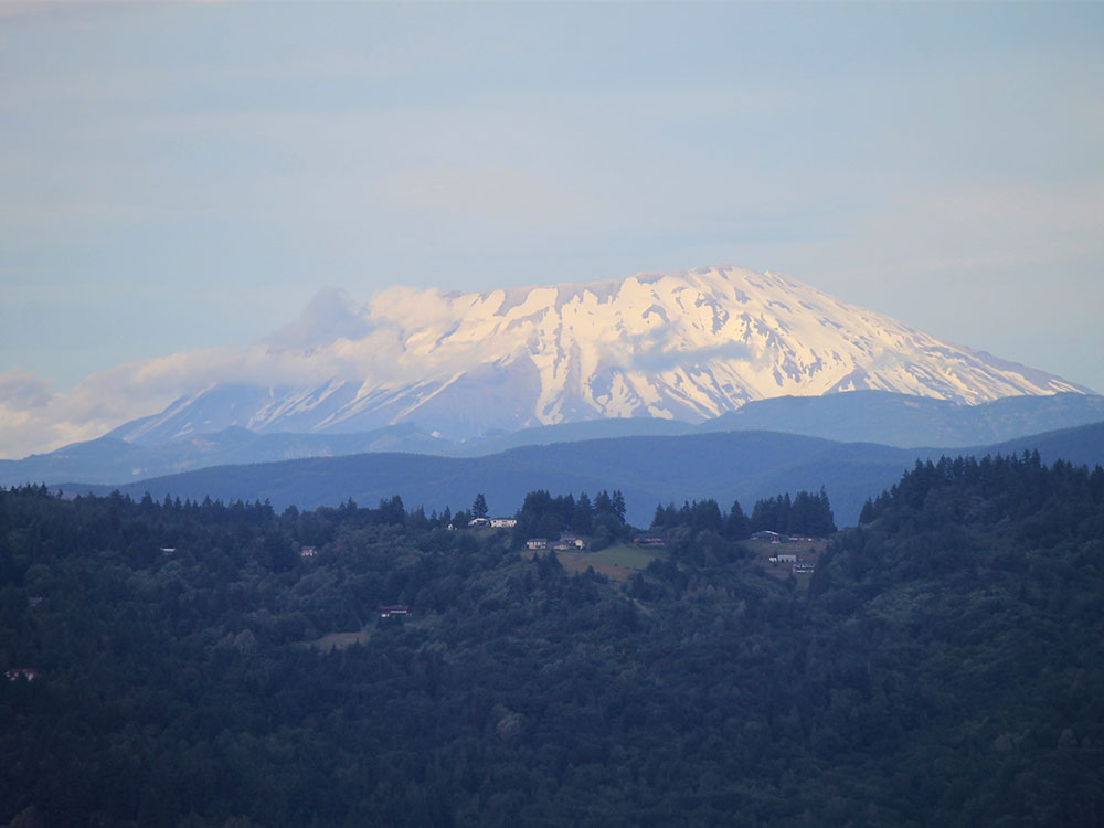
Mount St. Helens (known as Lawetlat'la to the Indigenous Cowlitz people, and Loowit or Louwala-Clough to the Klickitat) is an active stratovolcano located in Skamania County, Washington, in the Pacific Northwest. It is 52 miles (83 km) northeast of Portland, Oregon, and 98 miles (158 km) south of Seattle. Mount St. Helens takes its English name from the British diplomat Lord St Helens, a friend of explorer George Vancouver who made a survey of the area in the late 18th century. The volcano is located in the Cascade Range and is part of the Cascade Volcanic Arc, a segment of the Pacific Ring of Fire.
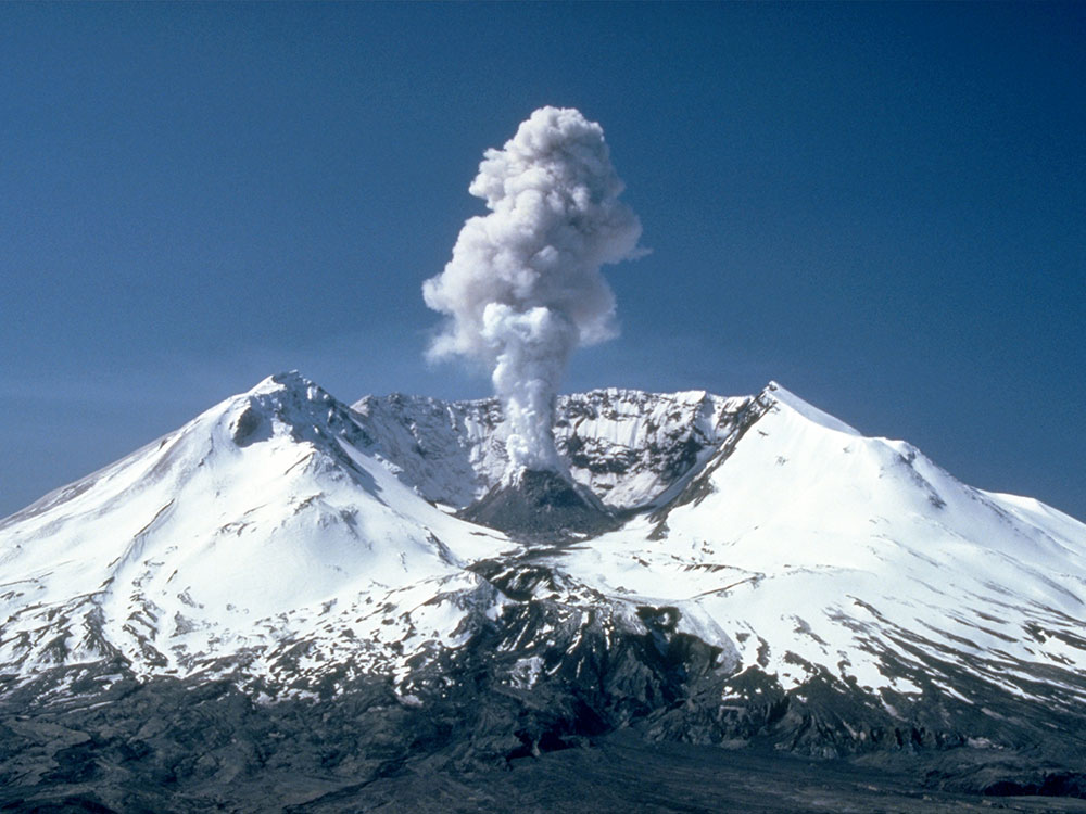
Mount St. Helens is most famous for its major eruption on May 18, 1980, the deadliest and most economically destructive volcanic event in U.S. history. Fifty-seven people were killed; 200 homes, 47 bridges, 15 miles (24 km) of railways, and 185 miles (298 km) of highway were destroyed. A massive debris avalanche, triggered by an earthquake of magnitude 5.1, caused a lateral eruption that reduced the elevation of the mountain's summit from 9,677 ft (2,950 m) to 8,363 ft (2,549 m), leaving a 1 mile (1.6 km) wide horseshoe-shaped crater. The debris avalanche was 0.6 cubic miles (2.5 km3) in volume.
Ever since its main eruption, it had continuous volcanic activity until 2008. Despite this, geologists predict that future eruptions will be more destructive, since the configuration of the lava domes there require more pressure to erupt. Despite the dangers, Mount St Helens is a popular hiking spot, and is climbed year round.
Geographic setting and description
Mount St. Helens is 34 miles (55 km) west of Mount Adams, in the western part of the Cascade Range. Considered "brother and sister" mountains, the two volcanoes are approximately 50 miles (80 km) from Mount Rainier, the highest of Cascade volcanoes. Mount Hood, the nearest major volcanic peak in Oregon, is 60 miles (100 km) southeast of Mount St. Helens.
Mount St. Helens is geologically young compared with the other major Cascade volcanoes. It formed only within the past 40,000 years, and the summit cone present before its 1980 eruption began rising about 2,200 years ago. The volcano is considered the most active in the Cascades within the Holocene epoch, which encompasses roughly the last 10,000 years.
May 18, 1980 eruption
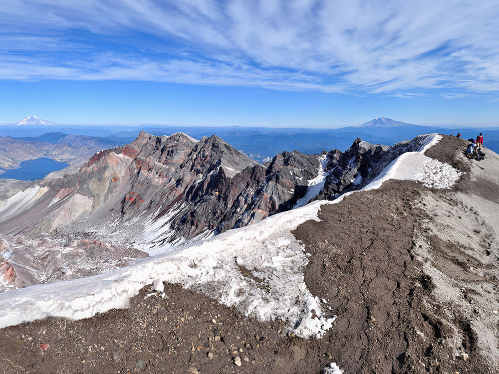
Before May 18, 1980, Mount St. Helens' summit altitude of 9,677 feet (2,950 meters) made it the fifth highest peak in Washington State. The conical snow covered mountain was often referred to as the Mount Fuji of America. The May 18, 1980 eruption transformed the mountain and surrounding landscape significantly. The volcano lost an estimated 3.4 billion cubic yards (0.63 cubic mile) of its cone (about 1,300 feet or 396 meters in height), leaving behind a horseshoe-shaped crater (open to the north), with the highest part of the crater rim on the southwestern side at 8,365 feet (2,550 meters) elevation. Today the summit of Mount St. Helens offers climbers a breathtaking view of neighboring cascade peaks, the crater formed by the 1980 eruption and surrounding areas.
Climbing and recreation
Mount St. Helens is a popular climbing destination for both beginning and experienced mountaineers. The peak is climbed year-round, although it is more often climbed from late spring through early fall. All routes include sections of steep, rugged terrain. A permit system has been in place for climbers since 1987. A climbing permit is required year-round for anyone who will be above 4,800 feet (1,500 m) on the slopes of Mount St. Helens.
Mount St. Helens National Volcanic Monument
Mount St. Helens National Volcanic Monument includes the area around Mount St. Helens in Washington. It was established on August 27, 1982 by U.S. President Ronald Reagan following the 1980 eruption. The 110,000 acre (445 km2) National Volcanic Monument was set aside for research, recreation, and education. Inside the Monument, the environment is left to respond naturally to the disturbance.
Since then, many trails, viewpoints, information stations, campgrounds, and picnic areas have been established to accommodate the increasing number of visitors each year. Beginning in 1983, visitors have been able to drive to Windy Ridge, only 4 miles (6.4 km) northeast of the crater. Mountain climbing to the summit of the volcano has been allowed since 1986.
The Mount St. Helens Visitor Center at Silver Lake, about 30 miles (48 km) west of Mount St. Helens and five miles (8 km) east of Interstate 5 (outside the monument), opened in 1987 and has been operated by the Washington State Park System since October 2000. Exhibits include the area's culture and history, and the natural history and geology of the volcano and the eruption, including the recovery of the area's vegetation and animal life. The Center includes a theater, a gift shop and outdoor trails. By the end of 1989, the Center had hosted more than 1.5 million visitors. A small admission fee is charged. The Center was formerly operated by the U.S. Forest Service.
Johnston Ridge Observatory
The Johnston Ridge Observatory is located 52 miles (84 km) east of Castle Rock, Washington, at the end of Washington State Route 504, four miles from the mountain. Exhibits focus on the geologic history of the volcano, eyewitness accounts of the explosion, and the science of monitoring volcanic activity. Two movies and ranger-led programs are available every hour. A half-mile paved trail provides views of the lava dome, crater, pumice plain, and landslide deposit, with access to hiking trails in the restricted area.
Windy Ridge
Windy Ridge is the closest view point accessible to the general public. Beginning in the summer of 1983, visitors have been able to drive to Windy Ridge, on U.S. Forest Service Road 99, only 4 miles (6.4 km) northeast of the crater. From this vantage point overlooking Spirit Lake, people see not only the evidence of a volcano's destruction, but also the remarkable, gradual (but faster than originally predicted) recovery of the land as revegetation proceeds and wildlife returns.
Ape Cave
Ape Cave is a lava tube located in Gifford Pinchot National Forest just to the south of Mount St. Helens in Washington state. Its passageway is the longest continuous lava tube in the continental United States and the third longest (in total mapped length) lava tube in North America at 2.5 miles (4,023 meters). Ape Cave is a popular hiking destination with beautiful views of the Mount St. Helens lahar region. Lava tubes are an unusual formation in this region, as volcanoes of the Cascade Range are mostly stratovolcanos and do not typically erupt with pahoehoe (fluid basalt).
The cave was discovered circa 1951 by Lawrence Johnson, a logger, when he noticed a tree that "looked wrong." After investigating the tree, he discovered it tilted into a lava tube collapse. A few days later, Johnson brought the Reese family back to the cave, and Harry Reese was lowered to the floor and became the first person to explore the interior. Subsequent explorations were conducted by members of the Mount St. Helens Apes, a local Boy Scout troop. Ape Cave Trail No. 239, which runs along the interior of the cave, is a National Recreation Trail receiving 170,000 visitors each year.
Monitor Ridge Climbing Route
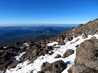
The standard hiking/mountaineering route in the warmer months is the Monitor Ridge Route, which starts at the Climbers Bivouac. This is the most popular and crowded route to the summit in the summer and gains about 4,600 feet (1,400 m) in approximately 5 miles (8 km) to reach the crater rim. Although strenuous, it is considered a non-technical climb that involves some scrambling. Most climbers complete the round trip in 7 to 12 hours.
The Monitor Ridge Climbing Route is the primary route used by climbers during the summer to reach Mount St Helens Summit. It is a non-technical scramble, gaining 4,500 feet in 5 miles. Most climbers complete the round trip in 7 to 12 hours.
The climbing route used in the summer months begins at Climber's Bivouac south of the volcano. At 3,700 feet elevation, Climber's Bivouac has the highest vehicle access on Mount St. Helens. Start on Ptarmigan Trail #216A which climbs 1,100 feet in 2 1/4 miles to timberline at 4,800 feet elevation.
Above timberline, the route generally follows Monitor Ridge, climbing steeply through lava flows and loose pumice and ash. From timberline the route is marked with large wooden posts to about 7,000 feet elevation. The upper 1,300 feet of the route is unmarked and covered with loose, rock, pumice and ash. On your descent, take care to stay on route. A minor detour may put you far off route at timberline.
Hiking Permits for Crater
November 1 thru March 31, climbing permits are free of charge and are self issue at the Climbing Registers located at the Marble Mountain Sno-Park and Climbers Bivouac. All persons traveling above 4800 ft are required to have a climbing permit. April 1st through October 31st, Climbing Fees are in effect. Permits are $22.00 per person. Climbing Permits are available in advance on-line only at Recreation.gov. In 2021, permits will be released one month at at time for purchase. Permits for April go on sale on March 1, 2021 at 7:00 am Pacific Time. Permits for May go on sale April 1, etc. This is a change from prior years. May 15 though October 31st, a climbing quota is in effect with a limit of 100 climbers per day. Forest Road 830 to Climber's Bivouac is gated normally until mid-June to the beginning of July, depending on when the road melts out.
This article uses material from the Wikipedia article "Mount St. Helens", which is released under the Creative Commons Attribution-Share-Alike License 3.0
This article uses material from the Wikipedia article "Mount St. Helens National Volcanic Monument", which is released under the Creative Commons Attribution-Share-Alike License 3.0
This article uses material from fs.usda.gov "Mount St. Helens National Volcanic Monument"
Featured Trails
Jeff P from Berkeley, CA, USA, CC BY 2.0, via Wikimedia Commons; Image Size Adjusted
.jpg)
Monitor Ridge/ Ptarmigan Trail #216A via Climber's Bivouac Trailhead
8.2 miles round-trip, 4583 feet elevation Standard hiking/mountaineering route in the warmer months to Mount St Helens crater. Considered a non-technical climb that involves some scrambling.
-thumbnail-400.jpg)
Forest Service, USDA, Public domain, via Wikimedia Commons; Image Size Adjusted
.jpg)
Ape Cave Trail
3 miles round-trip, 433 feet elevation
Longest continuous lava tube in the continental United States and the third longest (in total mapped length) lava tube in North America.
