Park and caves featuring cave with passages totaling about 15,000 feet, formed in marble and activities include cave touring, hiking, photography, and wildlife viewing
General Information
Oregon Caves National Monument and Preserve is a protected area in the northern Siskiyou Mountains of southwestern Oregon. The 4,554-acre (1,843 ha) park, including the marble cave, is 20 miles (32 km) east of Cave Junction, on Oregon Route 46. The protected area, managed by the National Park Service (NPS), is in southwestern Josephine County, near the Oregon-California border.
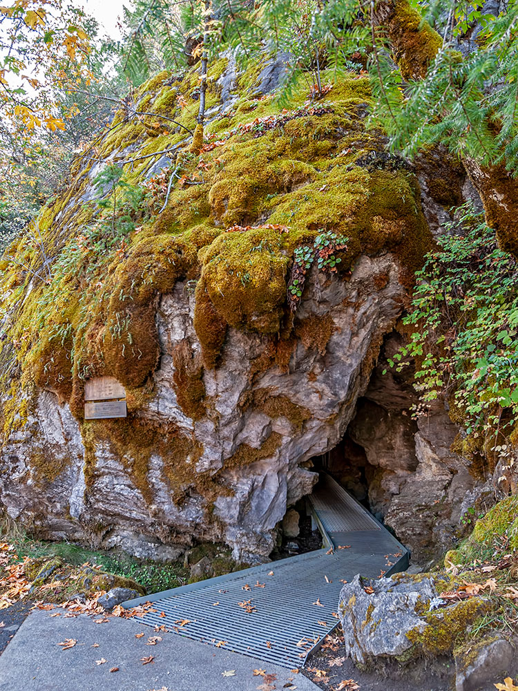
Elijah Davidson, a resident of nearby Williams, discovered the cave in 1874. Over the next two decades, private investors failed in efforts to run successful tourist ventures at the publicly owned site. After passage of the Antiquities Act by the United States Congress, in 1909 President William Howard Taft established Oregon Caves National Monument, to be managed by the United States Forest Service (USFS). The growing popularity of motor vehciles, construction of paved highways, and promotion of tourism by boosters from Grants Pass led to large increases in cave visitation during the late 1920s and thereafter. Among the attractions at the remote monument is the Oregon Caves Chateau, a six-story hotel built in a rustic style in 1934. It is a National Historic Landmark and is part of the Oregon Caves Historic District within the monument. The NPS, which assumed control of the monument in 1933, offers tours of the cave from mid-April through early November. In 2014, the protected area was expanded by about 4,000 acres (1,600 ha) and re-designated a National Monument and Preserve. At the same time, the segment of the creek that flows through the cave was renamed for the mythological Styx and added to the National Wild and Scenic Rivers System.
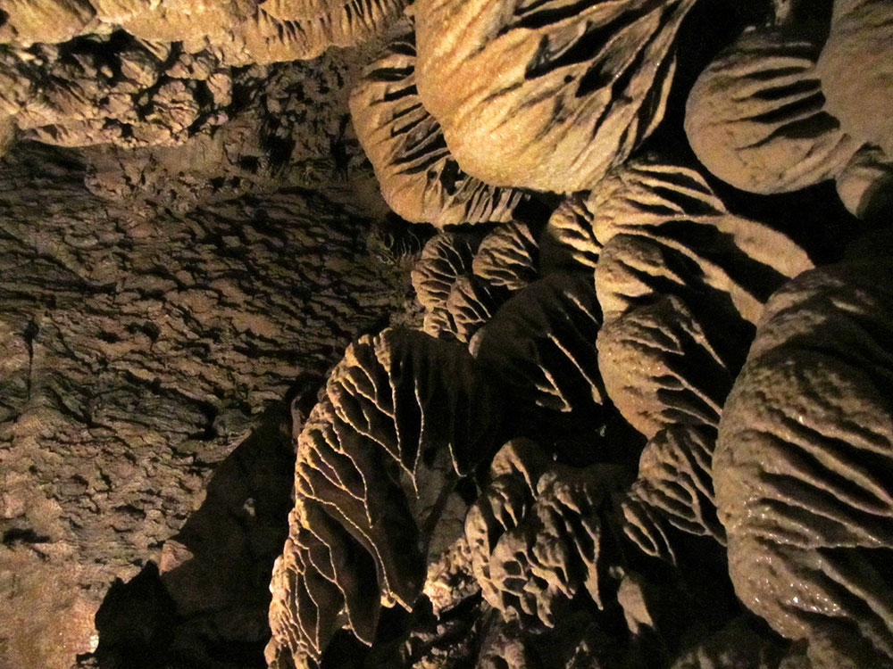
Oregon Caves is a solutional cave, with passages totaling about 15,000 feet (4,600 m), formed in marble. The parent rock was originally limestone that metamorphosed to marble during the geologic processes that created the Klamath Mountains, including the Siskiyous. Although the limestone formed about 190 million years ago, the cave itself is no older than a few million years. Valued as a tourist cave, the cavern also has scientific value; sections of the cave that are not on tour routes contain fossils of national importance.
Activities at the park include cave touring, hiking, photography, and wildlife viewing. One of the park trails leads through the forest to Big Tree, which at 13 feet (4.0 m) is the widest Douglas fir known in Oregon. Lodging and food are available at The Chateau and in Cave Junction. Camping is available in the preserve at the Cave Creek Campground, at a local USFS campground, and private sites in the area.
Oregon Caves National Monument and Preserve is in the Siskiyou Mountains, a coastal range that is part of the Klamath Mountains of northwestern California and southwestern Oregon. The monument consists of 484 acres (196 ha) in the Rogue River - Siskiyou National Forest, about 6 miles (10 km) north of the Oregon-California border in Josephine County. Elevations within the monument range from 3,680 to 5,480 feet (1,120 to 1,670 m). Mount Elijah in the preserve rises to 6,390 feet (1,950 m).
In December 2014 as part of the National Defense Authorization Act for Fiscal Year 2015, the U.S. Congress enlarged the protected area that includes the cave and changed its name from Oregon Caves National Monument to Oregon Caves National Monument and Preserve. The preserve covers 4,070 acres (1,650 ha), and both it and the monument, which abuts the preserve, are administered by the same staff.
By highway, Oregon Caves is 55 miles (89 km) southwest of Grants Pass, 300 miles (480 km) south of Portland and 450 miles (720 km) north of San Francisco. The caves are 20 miles (32 km) east of the small city of Cave Junction via Oregon Route 46 off U.S. Route 199. The main cave has known passages totaling about 15,000 feet (4,600 m) in length. Eight separate smaller caves have also been discovered in the monument.
Runoff from the heavily wooded monument forms small headwater streams of the Illinois River, a major tributary of the Rogue River. One of five small springs in the monument becomes Upper Cave Creek, which flows on the surface before disappearing into its bed and entering the cave. Supplemented by water entering the cave from above, the stream emerges from the main entrance as Cave Creek. Within the cave, Cave Creek is known as the River Styx, named for the river Styx of Greek mythology connecting Earth to the Underworld. In late 2014, Congress added the River Styx to the National Wild and Scenic Rivers System, which added a level of protection aimed at keeping the stream free-flowing in perpetuity. It is the only subterranean river in the Wild Rivers system.
Most caves created from dissolved rocks are formed in limestone or dolomite, but Oregon Caves was formed in marble. Of the more than 3,900 cave systems managed by the NPS, only those in Oregon Caves National Monument and Preserve, Kings Canyon National Park, and Great Basin National Park have marble caves.
The parent rock in which the cave developed was formed about 190 million years ago as limestone that was part of a tectonic plate beneath the Pacific Ocean. Granitic plutons intruded this part of the ocean crust, the Applegate terrane, about 160 million years ago. As the oceanic crust carrying the terrane subducted under the North American plate, the terrane accreted onto the North American Plate and the limestone was subjected to heat and pressure that metamorphosed it to marble. Further tectonic movements eventually lifted the marble to about 4,000 feet (1,200 m) above sea level. The marble block containing the cave is at least 1,080 feet (330 m) long, 490 feet (150 m) wide, and about 390 feet (120 m) high.
The cave's creation took place long after the marble formed. As groundwater seeped into cracks in the marble, it eventually dissolved enough rock to expand some of the cracks to the size of tunnels. Generally, the age of a cave cannot be determined directly because the cave itself is an empty space, but scientists can sometimes determine the age of speleothems or sediments in a cave. An early 21st-century study of speleothem development in Oregon Caves focused on the past 380,000 years. Based on the available evidence, the cave is thought to be at least a million years old and "probably not much older than a few million" years.
3). Caves often develop when slightly acidic groundwater dissolves calcite along natural fractures in the rock. A reversal of the dissolving process can create flowstone and dripstone such as stalactites, which hang from cave ceilings like icicles, and stalagmites, cone-shaped masses that form on cave floors, usually directly below stalactites. These structures form when acidic groundwater with a high concentration of dissolved calcite drips slowly from the ceiling of an air-filled cave, becomes less acidic, and leaves some of its calcite behind as a solid precipitate. Oregon Caves includes a variety of cave formations created through precipitation of calcite. Although many of the speleothems in the public sections of the cave have been broken, discolored by human skin oils, or otherwise damaged, the narrow twisting passages of the "show cave" have been largely preserved.
The cave is not pure marble. Streams have deposited silts and gravels from the surface. Dikes of diorite, an igneous rock that was part of a pluton, and shales and sandstones, sedimentary rocks interbedded with the marble, are part of the cave.
The monument has more than 50 paleontological sites ranging in age from Late Pleistocene to Holocene. A fossil of a grizzly bear more than 50,000 years old and a jaguar fossil between 40,000 and 20,000 years old have been found in the cave. Other fossils include amphibians, and rare finds of the mountain beaver and the blue grouse. The monument's mammalian fossils, found in non-public sections of the cave, are of national significance.
Located within the Klamath-Siskiyou region, known for its high biodiversity, the monument supports 391 vascular plant species as well as many species of bryophyte, lichen, and macrofungi. Trees in the monument include Douglas fir, oak, white fir, and alder. Among the oldest trees is Big Tree, thought to be the widest Douglas fir in the state. It is 41 feet (12 m) in circumference near the base. Its age is estimated at 600 to 800 years, and it was described in the 1930s as 14 feet (4.3 m) in diameter. The monument contains no plants with special conservation status.
Species lists for the park include about 50 mammals, 86 birds, 11 reptiles and amphibians, 8 bats, more than 200 arthropods, 8 snails and slugs, 75 butterflies, more than 55 moths, and 8 aquatic macroinvertebrates. Of these species, 160 are found inside the cave. Outside the cave, the black-tailed deer, Steller's jay, the common raven, and Townsend's chipmunk are among animals often seen in the park. Less commonly sighted are the black bear, cougar, northern flying squirrel, and Pacific giant salamander. Springs and other wet places support flatworms, frogs, and snails.
Animal species in the park with special conservation status are the northern spotted owl, California mountain kingsnake, tailed frog, Del Norte salamander, northern goshawk, olive-sided flycatcher, little willow flycatcher, Siskiyou gazelle beetle, and Pacific fisher. Five at-risk bat species are found in the cave: Townsend's big-eared bat, and the long-eared, fringed, long-legged, and Yuma myotis.
sometimes blocks the road to the park, and the visitor center is open when the cave is open for tours. Cave tours are usually offered from mid-April to early November, but the schedule depends in spring and fall on weather conditions. The Illinois Valley Visitor Center in Cave Junction, managed by the IVCDO under an NPS contract, also has information about the cave.
Cave-tour tickets are available online through the Recreation.gov website, and a limited number of tour tickets may sometimes be had first-come, first-served. Tours vary in length and duration. The basic ranger-guided "discovery cave tour", 90 minutes long, requires negotiating more than 500 steep and uneven stairs and passageways with as little as 45 inches (110 cm) between floor and ceiling. The NPS offers a limited number of off-trail "introduction to caving" tours by reservation only.
Since the cave is only 44 °F (7 °C) inside regardless of the outdoor temperature, the NPS recommends warm clothing for its tours. Good walking shoes are needed to negotiate slippery and uneven surfaces. Not allowed on the tours are flashlights, backpacks, large purses, tripods, or pets. To protect bats from white nose syndrome, visitors must not take any clothing or equipment into Oregon Caves that have previously entered any other cave or mine.
Lodging is available in the monument at the Chateau, which has 23 rooms to rent. Several hiking trails wind through the monument and adjacent forest lands. Big Tree Trail, 3.3 miles (5.3 km) long, gains 1,100 feet (340 m) in elevation between the visitor center and Big Tree. No Name Trail, 1.3 miles (2.1 km) long, begins behind the visitor center, follows Cave Creek, crosses it, and then climbs steeply to the west side of the monument. Two short side trails lead from the main trail to waterfalls along No Name Creek. Cliff Nature Trail, passing over marble outcrops and through fir forests, winds for about 1 mile (1.6 km) from near the cave entrance past the cave exit to Big Tree Trail. Old Growth Trail, 0.8 miles (1.3 km) long, links the Chateau and visitor center to the main parking lot. Other named trails entering the park include Cave Creek, Mt. Elijah, and Limestone. In 2012, the Oregon Caves Historic District was expanded to include several segments of the trail system.
Hotels, bed and breakfasts, motels, and resorts in the vicinity offer a variety of accommodations. Although no camping is allowed in the monument, the NPS maintains the Cave Creek Campground within the preserve. Additionally, the USFS maintains a campground nearby, and there are private campgrounds and recreational vehicle parks in the vicinity. The Chateau, generally open from early May to late October, has a restaurant, coffee shop, and delicatessen, and Cave Junction has several restaurants. The monument grounds include several picnic tables.
This article uses material from the Wikipedia article "Oregon Caves National Monument and Preserve", which is released under the Creative Commons Attribution-Share-Alike License 3.0
.jpg)