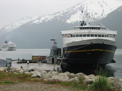

State-operated ferry system connecting coastal communities through scenic routes that transport passengers, vehicles, and goods across Alaska’s waterways.
General Information
Additional fees apply for vehicles, cabins, and amenities
Juneau
Anchorage (via connecting routes)
How to Get There
From Seattle (90 mi to Bellingham terminal): Drive north on I-5 to Bellingham, then board the ferry to access coastal Alaska communities along the marine highway.
Overview
The Alaska Marine Highway is a state ferry system, run out of Ketchikan, that connects Southeast Alaska and coastal communities on the Southwest Alaska route to Bellingham, Washington and Prince Rupert, British Columbia. It is one of the few ferry systems in the U.S. that exists for basic transportation, and it doubles as one of the cheapest and most scenic ways to see the Inside Passage. Ships are built for multi-day voyages, with cabins, cafeterias, and a solarium, and you can take your vehicle.
Routes
- Southeast mainline: Bellingham or Prince Rupert to Ketchikan, Wrangell, Petersburg, Sitka, Juneau, Haines, and Skagway, often taking more than a day
- Cross-gulf sailings: the MV Kennicott, since 1998, links Southeast with Prince William Sound (Whittier and Cordova)
- Southwest system: Prince William Sound, Kodiak Island, the Alaska Peninsula, and the Aleutians, with the MV Tustumena
- Day boats: the Lynn Canal run between Juneau, Haines, and Skagway in summer
This article uses material from the Wikipedia article "Alaska Marine Highway", which is released under the Creative Commons Attribution-Share-Alike License 3.0