Site protects over 3,000 acres of historic overland trail remnants, mixed-grass prairie, rugged badlands, towering bluffs and riparian area along the North Platte River
General Information
All Park Hours: Sunrise-Sunset
These hours are for the grounds, picnic area, and trails only
Scotts Bluff Summit Road Hours: Daily 9am to 4pm
Extended Summer Summit Road Hours: Daily 9am to 5:30pm
Visitor Center: Daily 8:30am to 4:30pm
How to Get There
From Denver, CO (200 miles): Take 15th St and Tremont Pl to W Colfax Ave. Follow I-76 E to CO-52 E/State Hwy 52 E in Morgan County. Take exit 80 from I-76 E. Continue on CO-52 E/State Hwy 52 E to Weld County. Continue on CO-71 N. Take NE-71/State Hwy 71 to Co Rd 21 in Gering. Continue on Co Rd 21 to destination.
Overview
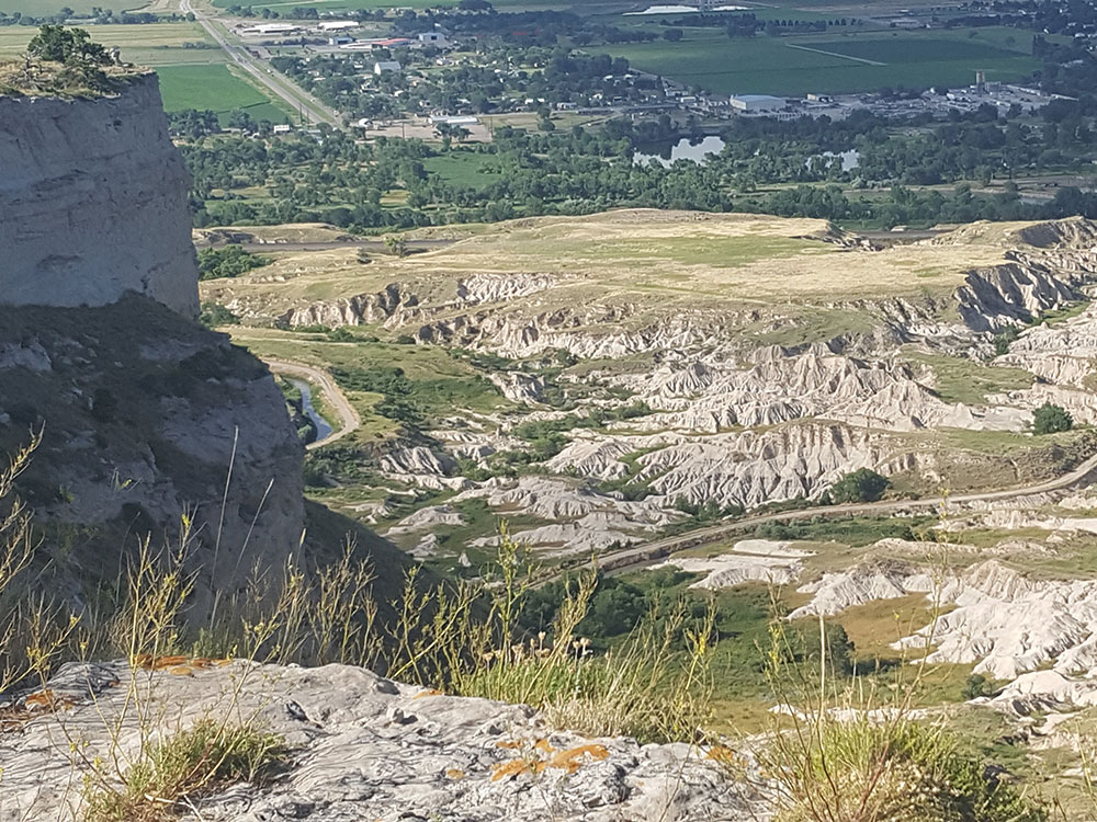
Scotts Bluff National Monument is located west of the City of Gering in western Nebraska. This National Park Service site protects over 3,000 acres of historic overland trail remnants, mixed-grass prairie, rugged badlands, towering bluffs and riparian area along the North Platte River.
The monument's north bluff is named after Hiram Scott, who was a clerk for the Rocky Mountain Fur Company and died near the bluff in 1828. The bluff served as an important landmark on the Oregon Trail, California Trail and Pony Express Trail, and was visible at a distance from the Mormon Trail. Over 250,000 westward emigrants passed by Scotts Bluff between 1843 and 1869. It was the second-most referred to landmark on the Emigrant Trails in pioneer journals and diaries.
Although called "Scotts Bluff National Monument," the site includes two separate bluffs, "South Bluff" and the northern bluff called "Scotts Bluff." There are five major outcroppings on the bluffs, known as Dome Rock, Crown Rock, Sentinel Rock, Eagle Rock and Saddle Rock. The area between Scotts Bluff and the North Platte River is known as the "Badlands."
The North Overlook Trail is a 0.5-mile (0.80 km) 564 ft paved trail that leaves from the summit parking lot and overlooks the North Platte River Valley. Visitors can reach the highest point on the bluff at 4,659 feet (1,420 m) above sea level.
The South Overlook Trail is a 0.4-mile (0.64 km) paved trail that leaves from the summit parking lot towards the south. From the overlook, visitors can see the Visitor Center and Mitchell Pass.
Saddle Rock Trail begins at the Visitor Center and climbs 435 feet (133 m) in 1.6 miles (2.6 km). The first third of the trail is relatively level from the Visitor Center to Scott's Spring. From here, the trail climbs rapidly most of the 435 feet (133 m) in 0.8 miles (1.3 km) to the summit parking lot.
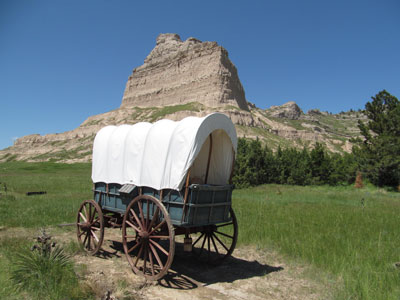
The Oregon Trail Pathway is a short trail ascending 85 feet (26 m) in 0.5 miles (0.80 km). The trail begins at the display of a Murphy and Conestoga wagons and ends in Mitchell Pass.
The Prairie View Trail is the only trail available to users other than hikers. It runs from the Visitor Center to the eastern boundary of the park. It drops 50 feet (15 m) in 1.2 miles (1.9 km).
Built in the 1930's, the Summit Road is the oldest concrete road in the State of Nebraska and gives visitors a chance to reach the top of the bluff by automobile. This 1.6 mile drive features scenic views and the only three vehicular tunnels in the state. It is narrow with sharp curves. Visitors have the option to access the summit using Summit Shuttle. The Summit Shuttle is available to visitors seasonally and depending on staffing availability. During the 7-10 minute drive, a park ranger will share stories about the natural, cultural, and historical resources of the park.
The area within Scotts Bluff National Monument south of the Old Oregon Trail highway and directly across from the Visitor Center is known as "South Bluff". The summit of South Bluff is 4,692 feet above sea level and is a relatively unspoiled area of considerable scenic value, abounding in features of geological and botanical interest.
South Bluff rises above the flat prairie in geologic strata of sandstone, siltstone, volcanic ash and limestone. This area is unimproved and there are no improvements planned. Of the five notable rocks within the monument, South Bluff features three: Dome Rock, Crown Rock, and Sentinel Rock. It is not permitted to climb Dome Rock, Crown Rock or Sentinel Rock because of the dangerously soft nature of the Brule clay formation that makes up their steep walls.
At the western end of South Bluff is Mitchell Pass. This pass is formed with Sentinel Rock on the south side of the pass and Eagle Rock on the north. The eastern end of South Bluff gradually lowers in elevation, forming isolated prominences of which Dome Rock is the largest. The western end remains at a significant elevation above the prairie. Between Sentinel Rock and Crown Rock is a “gap” referred to as Coyote Pass. Coyote Pass is 4,331 feet above sea level. South Bluff geology is similar to Scotts Bluff (to the north) and also has similar vegetation.
The collection of bluffs was first charted by non-native people in 1812 by the Astorian Expedition of fur traders traveling along the river. The expedition party noted the bluffs as the first large rock formations along the North Platte River where the Great Plains started giving way to the foothills of the Rocky Mountains. Their findings were not widely communicated because of the War of 1812. Explorers rediscovered the route to the Rocky Mountains in 1823, and fur traders in the region relied on the bluffs as a landmark. European Americans named the north, and most prominent bluff, after Hiram Scott, a fur trader who died in 1828 near the bluffs. The local Native Americans had called it Me-a-pa-te, "the hill that is hard to go around."
Fur traders, missionaries, and military expeditions began regular trips past Scotts Bluff during the 1830s. Beginning in 1841, multitudes of settlers passed by Scotts Bluff on their way west along the Great Platte River Road to Oregon, and later California and Utah. All these groups used the bluff as a major landmark for navigation.
Although a natural gap existed between South Bluff and Scotts Bluff, the area was not easily traversed. So initially the Oregon Trail passed to the south of the Scotts Bluff area at Robidoux Pass and the Mormon Trail passed to the north of the bluff, on the other side of the North Platte River. In the early 1850s a road was constructed in the gap, which later became known as Mitchell Pass. Beginning in 1851, this new passage became the preferred route of the Oregon and California Trails; although the Mormon Trail continued to pass the bluff only at a distance. Who built the road through Mitchell Pass about 1850 is unknown, although one possibility includes soldiers from Fort Laramie. Many emigrants preferred this route rather than trying to traverse the badlands on the north side of the bluffs or detouring south to the older trail at Robidoux Pass. Use of the Emigrant Trail tapered off in 1869 after the trail was superseded by the completion of the transcontinental railroad.
The town of Gering, Nebraska, was founded near the base of the bluff in 1887, and the city of Scottsbluff was founded across the North Platte River from the bluff in 1900. Separated (or joined) by the river, the two cities have since grown together and now form the 6th-largest urban area in Nebraska.
Once permanent settlements had been established nearby, residents and travelers went to the bluff as a destination because of its extensive views of the flat land stretching to the east, the hills and mountains to the west, and the river valley in between. Developers built various trails up the bluff over the years, but most were precarious and dangerous. In the early 20th century, the National Park Service constructed a safer, more modern trail for improved access.
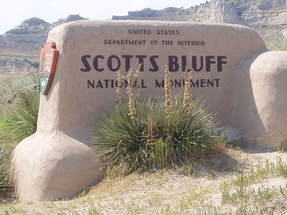
The Department of Interior designated Scotts Bluff and several nearby bluffs as a National Monument on December 12, 1919; they were placed for management under the National Park Service, created just three years prior.
The Oregon Trail Museum and Visitor Center was built at the base of the bluff which serves as a start for hiking tours of the bluffs. Exhibits focus on the westward expansion and pioneers, the drawings and paintings of William Henry Jackson, and the geology and paleontology of the region.
In the 1930s, a roadway leading to the top of Scotts Bluff was constructed by the Civilian Conservation Corps. The road goes through three tunnels on its way to the top and provides easy access to the summit.
This article uses material from the Wikipedia article "Scotts Bluff National Monument", which is released under the Creative Commons Attribution-Share-Alike License 3.0
This article uses material from nps.gov "Scotts Bluff National Monument"
_P7180288-1000.jpg)
-1000.jpg)