
Expansive rural region featuring black and green sand beaches, lava fields, coffee farms, and access to remote areas of Hawaiʻi Volcanoes National Park.
General Information
Kahuku Unit of Hawaiʻi Volcanoes National Park open Thursday to Sunday: 9am to 4pm
Individual sites may have specific hours
Hawaiʻi Volcanoes National Park entrance: $30 per vehicle, $25 per motorcycle, $15 per pedestrian or bicycle
Pass valid for 7 days
How to Get There
From Hilo (60–70 mi): Take Highway 11 southbound through Volcano Village and continue west to explore the Kaʻū District and its coastal and volcanic attractions.
Overview
Kaʻū is the southernmost and largest district on the Big Island, a remote, sparsely populated stretch of lava fields, ranchland and coast covering 922 square miles. It is best known for its dramatic shoreline, including the southernmost point in the United States, and for sections of Hawaiʻi Volcanoes National Park, including Kīlauea and Mauna Loa.
Kaʻū was one of the island’s six ancient districts (moku). Today its small communities include Pāhala, Nāʻālehu, Waiʻōhinu and Ocean View. Popular stops include Ka Lae (South Point), Punaluʻu Black Sand Beach, Papakōlea (Green Sand) Beach and Kamilo Beach.
This article uses material from the Wikipedia article "Kau, Hawaii", which is released under the Creative Commons Attribution-Share-Alike License 3.0
Featured Locations

Thomas Tunsch, CC BY-SA 3.0, via Wikimedia Commons; Image Size Adjusted

Papakōlea Beach
Secluded crescent-shaped beach nestled in a volcanic cinder cone, featuring rare green olivine sand and accessible only by a rugged coastal hike.
Famartin, CC BY-SA 4.0, via Wikimedia Commons; Image Size Adjusted

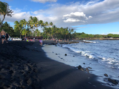
Punalu'u Black Sand Beach
Expansive shoreline of basalt sand formed by ancient lava flows, frequented by sea turtles and surrounded by palm trees and volcanic cliffs.